
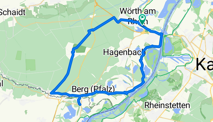
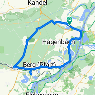
44_Wörth – Lauterbourg (F) – Wörth
A cycling route starting in Wörth am Rhein, Rhineland-Palatinate, Germany.
Overview
About this route
Kleiner Grenzverkehr (Pfalz–Elsass) Charakter: Exkursion in den Bienwald und in die Rheinauen auf ebenen Damm- und Waldwegen. Am Bahnhof Wörth sollte man sich genau orientieren, um in den östlichen Bienwald zu gelangen (Richtung!). Dann geht es geruhsam weiter. Am Ende der Tour in Maximiliansau heißt es wieder aufpassen. Verkehr: Wenige Ortsdurchfahrten mit schwachem Verkehr. Passender Reiseführer: KOMPASS 6290 Deutsche Weinstraße und Pfälzer Rheinebene, Heinz Egon Rösch, ISBN 978-3-85026-643-7
- -:--
- Duration
- 37.6 km
- Distance
- 71 m
- Ascent
- 71 m
- Descent
- ---
- Avg. speed
- ---
- Max. altitude

Route quality
Waytypes & surfaces along the route
Waytypes
Track
13.9 km
(37 %)
Road
7.5 km
(20 %)
Surfaces
Paved
29.3 km
(78 %)
Unpaved
6 km
(16 %)
Asphalt
29.3 km
(78 %)
Gravel
5.3 km
(14 %)
Route highlights
Points of interest along the route
 – Wörth\"")
Point of interest after 19.2 km
Rheinschiff bei Lauterbourg: hier an der Grenze ist der östlichste Punkt von Frankreich: Bei den Römern hieß der Ort Vicus Tribunci. Er lag an der bedeutenden Römerstraße von Mainz nach Strasbourg. Im Mittelalter bis 1794 gehörte Lauterbourg zum Bistum Speyer. Heute ist es ein im Département Bas-Rhi
 – Wörth\"")
Point of interest after 26 km
Neuburg (Fachwerkhaus) Fischerhäuschen: 1592 lag Neuburg noch auf der rechten Rheinseite. Nach einem schweren Unwetter bahnte sich der Rhein ein neues Bett, so dass der Ort für kurze Zeit auf einer Insel lag. Der alte westliche Rheinarm verlandete und Neuburg liegt seitdem auf der linken Rheinseite.
Continue with Bikemap
Use, edit, or download this cycling route
You would like to ride 44_Wörth – Lauterbourg (F) – Wörth or customize it for your own trip? Here is what you can do with this Bikemap route:
Free features
- Save this route as favorite or in collections
- Copy & plan your own version of this route
- Sync your route with Garmin or Wahoo
Premium features
Free trial for 3 days, or one-time payment. More about Bikemap Premium.
- Navigate this route on iOS & Android
- Export a GPX / KML file of this route
- Create your custom printout (try it for free)
- Download this route for offline navigation
Discover more Premium features.
Get Bikemap PremiumFrom our community
Other popular routes starting in Wörth am Rhein
 Knielingen, Karlsruhe nach Flachsmarkt, Rheinzabern
- Distance
- 32.4 km
- Ascent
- 87 m
- Descent
- 88 m
- Location
- Wörth am Rhein, Rhineland-Palatinate, Germany
 Wörth am Rhein - Worms
- Distance
- 113.2 km
- Ascent
- 0 m
- Descent
- 15 m
- Location
- Wörth am Rhein, Rhineland-Palatinate, Germany
 Wörth am Rhein - Kehl
- Distance
- 77.1 km
- Ascent
- 206 m
- Descent
- 168 m
- Location
- Wörth am Rhein, Rhineland-Palatinate, Germany
 Deutsch-Französische Maifahrt 2010 - RTF des RSC Wörth 1980 e.V. - 133 km Strecke
- Distance
- 123.8 km
- Ascent
- 601 m
- Descent
- 601 m
- Location
- Wörth am Rhein, Rhineland-Palatinate, Germany
 Eisenbahnstraße, Wörth am Rhein nach Rue Jacques Twinger, Drusenheim
- Distance
- 54.2 km
- Ascent
- 143 m
- Descent
- 126 m
- Location
- Wörth am Rhein, Rhineland-Palatinate, Germany
 Elsassrunde
- Distance
- 60.2 km
- Ascent
- 176 m
- Descent
- 187 m
- Location
- Wörth am Rhein, Rhineland-Palatinate, Germany
 Eisenbahnstraße, Wörth am Rhein nach Route du Rhin, Gambsheim
- Distance
- 62.9 km
- Ascent
- 140 m
- Descent
- 114 m
- Location
- Wörth am Rhein, Rhineland-Palatinate, Germany
 44_Wörth – Lauterbourg (F) – Wörth
- Distance
- 37.6 km
- Ascent
- 71 m
- Descent
- 71 m
- Location
- Wörth am Rhein, Rhineland-Palatinate, Germany
Open it in the app