

37_Schwenningen – Rottweil – Sulz
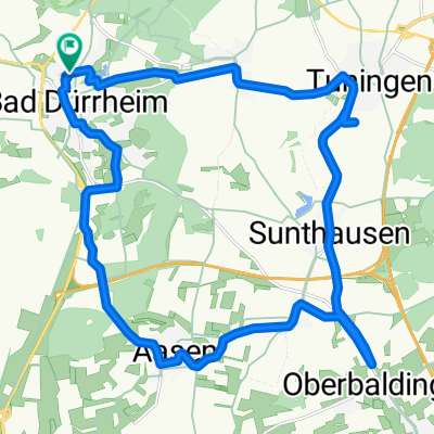
A cycling route starting in Bad Dürrheim, Baden-Wurttemberg, Germany.
Overview
About this route
From the source to the most beautiful double curve of the Neckar Character: Easy descent with insignificant intermediate climbs to Rottweil, then descent with occasionally noticeable intermediate climbs. Traffic: Outside urban areas, car-free paths prevail. Suitable travel guide: KOMPASS 6282 Neckartal-Radweg, Bernhard Pollmann, ISBN 978-3-85026-757-1
- -:--
- Duration
- 53.2 km
- Distance
- 166 m
- Ascent
- 449 m
- Descent
- ---
- Avg. speed
- ---
- Max. altitude

Route quality
Waytypes & surfaces along the route
Waytypes
Track
19.2 km
(36 %)
Quiet road
16.5 km
(31 %)
Surfaces
Paved
41.5 km
(78 %)
Unpaved
8 km
(15 %)
Asphalt
37.3 km
(70 %)
Gravel
5.9 km
(11 %)
Route highlights
Points of interest along the route

Point of interest after 1.6 km
Villingen-Schwenningen: Die Doppelstadt Villingen-Schwenningen am Ostrand des Naturparks Südschwarzwald ist die Hauptstadt der Schwarzwald-Baar und dank der Lage am Donau-Zufluss Brigach und am Neckarursprung ein Knotenpunkt von Wander- und Radwegen in alle Himmelsrichtungen. Bild-/ Textquelle: KOMP

Point of interest after 21 km
Rottweil: Älteste Stadt Baden-Württembergs. Rottweil hat einen der schönsten Altstadtkerne am Neckar bewahrt. Wie bei Freiburg im Breisgau und Villingen stand bei der Anlage der Stadt das „Zähringer Kreuz“ Pate; dieses Straßenkreuz schied die spätmittelalterliche Altstadt in vier Teile („Orte“). Die

Point of interest after 53.1 km
Sulz: Salz-Stadt am oberen Neckar im Naturpark Schwarzwald Nord/Mitte; der staatlich anerkannte Erholungsort ist Ausgangspunkt der Hohenzollernstraße zur Schwäbischen Alb und liegt an der Römerstraße Neckar–Alb–Aare. Der Name Sulz kommt vom Salz, das vom Mittelalter bis ins 19. Jh. das Leben und die
Continue with Bikemap
Use, edit, or download this cycling route
You would like to ride 37_Schwenningen – Rottweil – Sulz or customize it for your own trip? Here is what you can do with this Bikemap route:
Free features
- Save this route as favorite or in collections
- Copy & plan your own version of this route
- Sync your route with Garmin or Wahoo
Premium features
Free trial for 3 days, or one-time payment. More about Bikemap Premium.
- Navigate this route on iOS & Android
- Export a GPX / KML file of this route
- Create your custom printout (try it for free)
- Download this route for offline navigation
Discover more Premium features.
Get Bikemap PremiumFrom our community
Other popular routes starting in Bad Dürrheim
 Heidenhofen Rundweg 01
- Distance
- 16.5 km
- Ascent
- 202 m
- Descent
- 202 m
- Location
- Bad Dürrheim, Baden-Wurttemberg, Germany
 37_Schwenningen – Rottweil – Sulz
- Distance
- 53.2 km
- Ascent
- 166 m
- Descent
- 449 m
- Location
- Bad Dürrheim, Baden-Wurttemberg, Germany
 quellenroute
- Distance
- 48.1 km
- Ascent
- 252 m
- Descent
- 254 m
- Location
- Bad Dürrheim, Baden-Wurttemberg, Germany
 Vom Brigachtal über den Hochschwarzwald nach Rötenbach
- Distance
- 80.9 km
- Ascent
- 653 m
- Descent
- 652 m
- Location
- Bad Dürrheim, Baden-Wurttemberg, Germany
 Dürrheim - Donau - Aasen - Dürrheim
- Distance
- 25.3 km
- Ascent
- 49 m
- Descent
- 69 m
- Location
- Bad Dürrheim, Baden-Wurttemberg, Germany
 Fahrt nach Neresheim
- Distance
- 208.5 km
- Ascent
- 2,428 m
- Descent
- 2,633 m
- Location
- Bad Dürrheim, Baden-Wurttemberg, Germany
 Königsberger Straße 4, Bad Dürrheim nach Königsberger Straße 6, Bad Dürrheim
- Distance
- 25.1 km
- Ascent
- 222 m
- Descent
- 223 m
- Location
- Bad Dürrheim, Baden-Wurttemberg, Germany
 Bad Dürrheim Runde
- Distance
- 54.6 km
- Ascent
- 292 m
- Descent
- 291 m
- Location
- Bad Dürrheim, Baden-Wurttemberg, Germany
Open it in the app