

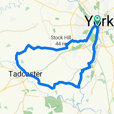
York v Route 65 to Selby BURN and back.
A cycling route starting in York, England, United Kingdom.
Overview
About this route
Route 65 to Selby, Trans Pennine Trail Rout 62 alongside canal to Burn (22 miles) Return v Thorpe Willoughby, Cawood rejoining R65 at Naburn, (42 miles) back to Morrisons.
If you use the bank top onto Selby take the 1st Left onto the main road. Not all Paved!- -:--
- Duration
- 68.7 km
- Distance
- 53 m
- Ascent
- 54 m
- Descent
- ---
- Avg. speed
- ---
- Max. altitude
Route quality
Waytypes & surfaces along the route
Waytypes
Cycleway
31.6 km
(46 %)
Road
13.1 km
(19 %)
Surfaces
Paved
41.2 km
(60 %)
Unpaved
1.4 km
(2 %)
Asphalt
41.2 km
(60 %)
Gravel
1.4 km
(2 %)
Undefined
26.1 km
(38 %)
Continue with Bikemap
Use, edit, or download this cycling route
You would like to ride York v Route 65 to Selby BURN and back. or customize it for your own trip? Here is what you can do with this Bikemap route:
Free features
- Save this route as favorite or in collections
- Copy & plan your own version of this route
- Sync your route with Garmin or Wahoo
Premium features
Free trial for 3 days, or one-time payment. More about Bikemap Premium.
- Navigate this route on iOS & Android
- Export a GPX / KML file of this route
- Create your custom printout (try it for free)
- Download this route for offline navigation
Discover more Premium features.
Get Bikemap PremiumFrom our community
Other popular routes starting in York
 Ampleforth (Malton) 2018-05-30
- Distance
- 114.9 km
- Ascent
- 353 m
- Descent
- 360 m
- Location
- York, England, United Kingdom
 Yorkshire
- Distance
- 243.3 km
- Ascent
- 886 m
- Descent
- 784 m
- Location
- York, England, United Kingdom
 Fridaythorpe (Pockington) 2018-12-19
- Distance
- 84 km
- Ascent
- 395 m
- Descent
- 391 m
- Location
- York, England, United Kingdom
 37 Monkgate, York to 33 Huntington Road, York
- Distance
- 16.1 km
- Ascent
- 6 m
- Descent
- 13 m
- Location
- York, England, United Kingdom
 York - Westow - York
- Distance
- 64.9 km
- Ascent
- 118 m
- Descent
- 114 m
- Location
- York, England, United Kingdom
 The Southern Loop
- Distance
- 43.2 km
- Ascent
- 72 m
- Descent
- 72 m
- Location
- York, England, United Kingdom
 York to Newton-upon-Ouse
- Distance
- 17.5 km
- Ascent
- 693 m
- Descent
- 697 m
- Location
- York, England, United Kingdom
 York - Crayke - York via Easingwold
- Distance
- 63.9 km
- Ascent
- 117 m
- Descent
- 115 m
- Location
- York, England, United Kingdom
Open it in the app