

09-11-2013_Day08
A cycling route starting in Jōetsu, Niigata, Japan.
Overview
About this route
09-11-2013_Day08
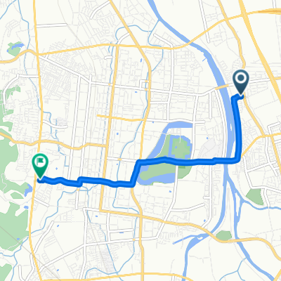
新瀉 上越市 -> 山形 寒河江 Joetsu, Niigata -> Sagae, Yamagata- -:--
- Duration
- 302.5 km
- Distance
- 863 m
- Ascent
- 771 m
- Descent
- ---
- Avg. speed
- ---
- Max. altitude

Continue with Bikemap
Use, edit, or download this cycling route
You would like to ride 09-11-2013_Day08 or customize it for your own trip? Here is what you can do with this Bikemap route:
Free features
- Save this route as favorite or in collections
- Copy & plan your own version of this route
- Split it into stages to create a multi-day tour
- Sync your route with Garmin or Wahoo
Premium features
Free trial for 3 days, or one-time payment. More about Bikemap Premium.
- Navigate this route on iOS & Android
- Export a GPX / KML file of this route
- Create your custom printout (try it for free)
- Download this route for offline navigation
Discover more Premium features.
Get Bikemap PremiumFrom our community
Other popular routes starting in Jōetsu
 寺町3丁目, 上越市へ大貫4丁目, 上越市
- Distance
- 5.3 km
- Ascent
- 129 m
- Descent
- 126 m
- Location
- Jōetsu, Niigata, Japan
 Innagural route on Kaze
- Distance
- 23.4 km
- Ascent
- 467 m
- Descent
- 466 m
- Location
- Jōetsu, Niigata, Japan
 久比岐自転車道 - 久比岐自転車道
- Distance
- 32 km
- Ascent
- 284 m
- Descent
- 288 m
- Location
- Jōetsu, Niigata, Japan
 1丁目 まで2丁目
- Distance
- 5 km
- Ascent
- 51 m
- Descent
- 82 m
- Location
- Jōetsu, Niigata, Japan
 09-11-2013_Day08
- Distance
- 302.5 km
- Ascent
- 863 m
- Descent
- 771 m
- Location
- Jōetsu, Niigata, Japan
 Draft Route
- Distance
- 11.5 km
- Ascent
- 141 m
- Descent
- 128 m
- Location
- Jōetsu, Niigata, Japan
 上越市~新潟市
- Distance
- 133.8 km
- Ascent
- 461 m
- Descent
- 462 m
- Location
- Jōetsu, Niigata, Japan
 寺町3丁目20-24, 上越市 to 国道253号, 上越市
- Distance
- 10.1 km
- Ascent
- 301 m
- Descent
- 314 m
- Location
- Jōetsu, Niigata, Japan
Open it in the app