

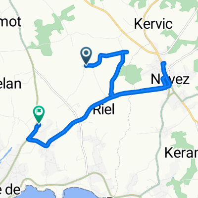
Strand Trefunc
A cycling route starting in Névez, Brittany Region, France.
Overview
About this route
06.09.15 16:13
- -:--
- Duration
- 4.9 km
- Distance
- 27 m
- Ascent
- 28 m
- Descent
- ---
- Avg. speed
- ---
- Max. altitude
Continue with Bikemap
Use, edit, or download this cycling route
You would like to ride Strand Trefunc or customize it for your own trip? Here is what you can do with this Bikemap route:
Free features
- Save this route as favorite or in collections
- Copy & plan your own version of this route
- Sync your route with Garmin or Wahoo
Premium features
Free trial for 3 days, or one-time payment. More about Bikemap Premium.
- Navigate this route on iOS & Android
- Export a GPX / KML file of this route
- Create your custom printout (try it for free)
- Download this route for offline navigation
Discover more Premium features.
Get Bikemap PremiumFrom our community
Other popular routes starting in Névez
 bretagne concaneau
- Distance
- 30 km
- Ascent
- 140 m
- Descent
- 140 m
- Location
- Névez, Brittany Region, France
 Route to Stang Quelfen, Trégunc
- Distance
- 10 km
- Ascent
- 52 m
- Descent
- 68 m
- Location
- Névez, Brittany Region, France
 Impasse de l'Usine À Goemon 1, Trégunc nach Sandaya Camping Les 2 Fontaines, Névez
- Distance
- 7.5 km
- Ascent
- 0 m
- Descent
- 7 m
- Location
- Névez, Brittany Region, France
 44 Route des Iris, Névez nach 41 Kerascoët, Névez
- Distance
- 1.2 km
- Ascent
- 10 m
- Descent
- 7 m
- Location
- Névez, Brittany Region, France
 Strand Trefunc
- Distance
- 4.9 km
- Ascent
- 27 m
- Descent
- 28 m
- Location
- Névez, Brittany Region, France
 NEVEZIENNE Rue de Kerilis 8, Névez
- Distance
- 28.2 km
- Ascent
- 198 m
- Descent
- 200 m
- Location
- Névez, Brittany Region, France
 Fahrt a la Plage de Trégunc
- Distance
- 7.1 km
- Ascent
- 51 m
- Descent
- 82 m
- Location
- Névez, Brittany Region, France
 De Hent Kerikel 27, Trégunc a Rue de Pen er Zal 4, Locmiquélic
- Distance
- 74.1 km
- Ascent
- 597 m
- Descent
- 617 m
- Location
- Névez, Brittany Region, France
Open it in the app