

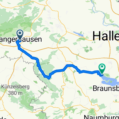
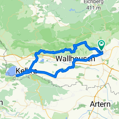
Kyffhäuser und Goldene Aue-Tour, mittlere Schwierigkeit
A cycling route starting in Sangerhausen, Saxony-Anhalt, Germany.
Overview
About this route
Beautiful route over the Kyffhäuser and through the Goldene Aue.
The route runs almost exclusively on bike and field paths, except from Auleben to Werther. Here you ride on a quiet, little-traveled country road.
The climb to the Kyffhäuser is somewhat strenuous but worthwhile.
Attention bikers! On the short stretch from Kyffhäuserkamm to the TV tower, you must ride on the road (about 1 km). Caution is advised as crazy motorcyclists speed past! The path is suitable for bike tourists and mountain bikers.
- -:--
- Duration
- 105.4 km
- Distance
- 513 m
- Ascent
- 513 m
- Descent
- ---
- Avg. speed
- ---
- Max. altitude
Route highlights
Points of interest along the route
Point of interest after 0 km
Startpunkt Markt Sangerhausen
Continue with Bikemap
Use, edit, or download this cycling route
You would like to ride Kyffhäuser und Goldene Aue-Tour, mittlere Schwierigkeit or customize it for your own trip? Here is what you can do with this Bikemap route:
Free features
- Save this route as favorite or in collections
- Copy & plan your own version of this route
- Split it into stages to create a multi-day tour
- Sync your route with Garmin or Wahoo
Premium features
Free trial for 3 days, or one-time payment. More about Bikemap Premium.
- Navigate this route on iOS & Android
- Export a GPX / KML file of this route
- Create your custom printout (try it for free)
- Download this route for offline navigation
Discover more Premium features.
Get Bikemap PremiumFrom our community
Other popular routes starting in Sangerhausen
 4. Südharztour Sangerhausen
- Distance
- 84.2 km
- Ascent
- 765 m
- Descent
- 765 m
- Location
- Sangerhausen, Saxony-Anhalt, Germany
 Schloßberge, Sangerhausen nach Wasserwerk, Mücheln (Geiseltal)
- Distance
- 55.8 km
- Ascent
- 342 m
- Descent
- 408 m
- Location
- Sangerhausen, Saxony-Anhalt, Germany
 Rund um Sangerhausen
- Distance
- 40.2 km
- Ascent
- 206 m
- Descent
- 223 m
- Location
- Sangerhausen, Saxony-Anhalt, Germany
 Kyffhäuser und Goldene Aue-Tour, mittlere Schwierigkeit
- Distance
- 105.4 km
- Ascent
- 513 m
- Descent
- 513 m
- Location
- Sangerhausen, Saxony-Anhalt, Germany
 Route nach Südharz
- Distance
- 56.4 km
- Ascent
- 552 m
- Descent
- 553 m
- Location
- Sangerhausen, Saxony-Anhalt, Germany
 493. Wickerode
- Distance
- 124.6 km
- Ascent
- 1,096 m
- Descent
- 1,063 m
- Location
- Sangerhausen, Saxony-Anhalt, Germany
 Roßla
Roßla- Distance
- 30.6 km
- Ascent
- 89 m
- Descent
- 95 m
- Location
- Sangerhausen, Saxony-Anhalt, Germany
 Sangerhausen-Grillenberg-Waldbad
- Distance
- 10.6 km
- Ascent
- 88 m
- Descent
- 3 m
- Location
- Sangerhausen, Saxony-Anhalt, Germany
Open it in the app