

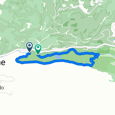
Javeriana-La Vorágine
A cycling route starting in Jamundí, Valle del Cauca Department, Colombia.
Overview
About this route
Average gradient of 3.8%
- -:--
- Duration
- 6.9 km
- Distance
- 209 m
- Ascent
- 4 m
- Descent
- ---
- Avg. speed
- ---
- Max. altitude
Route quality
Waytypes & surfaces along the route
Waytypes
Road
3.5 km
(51 %)
Cycleway
3.1 km
(45 %)
Surfaces
Paved
4.2 km
(61 %)
Asphalt
3.1 km
(45 %)
Paved (undefined)
1.1 km
(16 %)
Undefined
2.7 km
(39 %)
Continue with Bikemap
Use, edit, or download this cycling route
You would like to ride Javeriana-La Vorágine or customize it for your own trip? Here is what you can do with this Bikemap route:
Free features
- Save this route as favorite or in collections
- Copy & plan your own version of this route
- Sync your route with Garmin or Wahoo
Premium features
Free trial for 3 days, or one-time payment. More about Bikemap Premium.
- Navigate this route on iOS & Android
- Export a GPX / KML file of this route
- Create your custom printout (try it for free)
- Download this route for offline navigation
Discover more Premium features.
Get Bikemap PremiumFrom our community
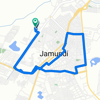
Other popular routes starting in Jamundí
 La boquería-La vorágine
- Distance
- 7.3 km
- Ascent
- 221 m
- Descent
- 17 m
- Location
- Jamundí, Valle del Cauca Department, Colombia
 Javeriana-La Vorágine
- Distance
- 6.9 km
- Ascent
- 209 m
- Descent
- 4 m
- Location
- Jamundí, Valle del Cauca Department, Colombia
 De Pico de Aguila a La Voragine Ini
- Distance
- 5.6 km
- Ascent
- 82 m
- Descent
- 638 m
- Location
- Jamundí, Valle del Cauca Department, Colombia
 Jamundí, Jamundí a Jamundí, Jamundí
- Distance
- 18 km
- Ascent
- 151 m
- Descent
- 151 m
- Location
- Jamundí, Valle del Cauca Department, Colombia
 De EcoParque Pance 4a entrada_2 a EcoParque Pance 4a entrada_2
- Distance
- 4.4 km
- Ascent
- 102 m
- Descent
- 112 m
- Location
- Jamundí, Valle del Cauca Department, Colombia
 Paseo lento
- Distance
- 3.7 km
- Ascent
- 164 m
- Descent
- 167 m
- Location
- Jamundí, Valle del Cauca Department, Colombia
 3.269, -76.546 a 3.269, -76.546
- Distance
- 10.1 km
- Ascent
- 45 m
- Descent
- 44 m
- Location
- Jamundí, Valle del Cauca Department, Colombia
 102 panamerica
- Distance
- 115 km
- Ascent
- 1,410 m
- Descent
- 635 m
- Location
- Jamundí, Valle del Cauca Department, Colombia
Open it in the app