
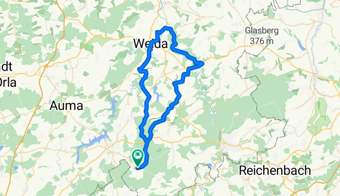
Pöllwitz - Berga(Elster) - Pöllwitz
A cycling route starting in Zeulenroda, Thuringia, Germany.
Overview
About this route
- -:--
- Duration
- 55.4 km
- Distance
- 509 m
- Ascent
- 509 m
- Descent
- ---
- Avg. speed
- ---
- Max. altitude
Continue with Bikemap
Use, edit, or download this cycling route
You would like to ride Pöllwitz - Berga(Elster) - Pöllwitz or customize it for your own trip? Here is what you can do with this Bikemap route:
Free features
- Save this route as favorite or in collections
- Copy & plan your own version of this route
- Sync your route with Garmin or Wahoo
Premium features
Free trial for 3 days, or one-time payment. More about Bikemap Premium.
- Navigate this route on iOS & Android
- Export a GPX / KML file of this route
- Create your custom printout (try it for free)
- Download this route for offline navigation
Discover more Premium features.
Get Bikemap PremiumFrom our community
Other popular routes starting in Zeulenroda
 Ortsstraße 4, Silberfeld nach Bauerfeindallee 1, Zeulenroda-Triebes
- Distance
- 24.2 km
- Ascent
- 231 m
- Descent
- 233 m
- Location
- Zeulenroda, Thuringia, Germany
 Untere Neustadt 24, Zeulenroda-Triebes nach Untere Neustadt 26, Zeulenroda-Triebes
- Distance
- 10.3 km
- Ascent
- 88 m
- Descent
- 102 m
- Location
- Zeulenroda, Thuringia, Germany
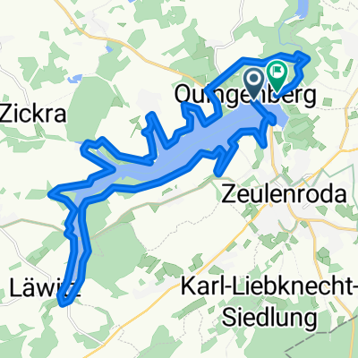
 Talsperre Zeulenroda
- Distance
- 20 km
- Ascent
- 155 m
- Descent
- 157 m
- Location
- Zeulenroda, Thuringia, Germany
 kaufland
- Distance
- 0.7 km
- Ascent
- 95 m
- Descent
- 15 m
- Location
- Zeulenroda, Thuringia, Germany
 Talsperre Zeulenroda
- Distance
- 20.3 km
- Ascent
- 293 m
- Descent
- 290 m
- Location
- Zeulenroda, Thuringia, Germany
 05.06.15 Zeulenroda - UW Roe
- Distance
- 78.8 km
- Ascent
- 611 m
- Descent
- 604 m
- Location
- Zeulenroda, Thuringia, Germany
 Kapellenweg 5E, Zeulenroda-Triebes nach Kapellenweg 5F, Zeulenroda-Triebes
- Distance
- 15.7 km
- Ascent
- 193 m
- Descent
- 191 m
- Location
- Zeulenroda, Thuringia, Germany
 Rund um die Talsperre Zeulenroda
- Distance
- 21 km
- Ascent
- 197 m
- Descent
- 197 m
- Location
- Zeulenroda, Thuringia, Germany
Open it in the app