

Dandenong Loop
A cycling route starting in Dandenong North, Victoria, Australia.
Overview
About this route
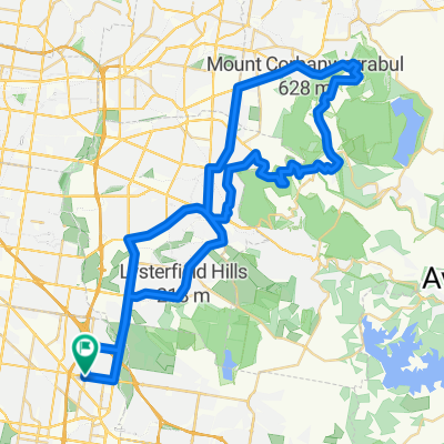
a loop of dandenong.
road,paved,dirt and gravel for mtb- -:--
- Duration
- 17.3 km
- Distance
- 42 m
- Ascent
- 41 m
- Descent
- ---
- Avg. speed
- ---
- Max. altitude

Route quality
Waytypes & surfaces along the route
Waytypes
Cycleway
8.3 km
(48 %)
Quiet road
4.5 km
(26 %)
Surfaces
Paved
9.7 km
(56 %)
Unpaved
0.3 km
(2 %)
Paved (undefined)
4.5 km
(26 %)
Asphalt
3.1 km
(18 %)
Route highlights
Points of interest along the route
Point of interest after 1 km
Bunnings Warehouse
Point of interest after 12.5 km
Dandenong Hospital
Continue with Bikemap
Use, edit, or download this cycling route
You would like to ride Dandenong Loop or customize it for your own trip? Here is what you can do with this Bikemap route:
Free features
- Save this route as favorite or in collections
- Copy & plan your own version of this route
- Sync your route with Garmin or Wahoo
Premium features
Free trial for 3 days, or one-time payment. More about Bikemap Premium.
- Navigate this route on iOS & Android
- Export a GPX / KML file of this route
- Create your custom printout (try it for free)
- Download this route for offline navigation
Discover more Premium features.
Get Bikemap PremiumFrom our community
Other popular routes starting in Dandenong North
 Dandenong Creek Trl, Dandenong North to 175 Cheltenham Rd, Dandenong
- Distance
- 22.7 km
- Ascent
- 48 m
- Descent
- 52 m
- Location
- Dandenong North, Victoria, Australia
 Noble Park to Cherry Hill Tavern (Doncaster) via Dandenong Creek, Eastlink, Mullum Mullum Trails
- Distance
- 32.2 km
- Ascent
- 301 m
- Descent
- 245 m
- Location
- Dandenong North, Victoria, Australia
 Short Dandenong Trail
- Distance
- 14.2 km
- Ascent
- 75 m
- Descent
- 29 m
- Location
- Dandenong North, Victoria, Australia
 Flat route
- Distance
- 23.5 km
- Ascent
- 238 m
- Descent
- 177 m
- Location
- Dandenong North, Victoria, Australia
 Dandenong Loop
- Distance
- 17.3 km
- Ascent
- 42 m
- Descent
- 41 m
- Location
- Dandenong North, Victoria, Australia
 Mt. Dandy Lop Via Montrose
- Distance
- 69.2 km
- Ascent
- 710 m
- Descent
- 709 m
- Location
- Dandenong North, Victoria, Australia
 Latham Cres to Hallam
- Distance
- 34.1 km
- Ascent
- 138 m
- Descent
- 137 m
- Location
- Dandenong North, Victoria, Australia
 Heyington Crescent 2, Noble Park North to Heyington Crescent 2, Noble Park North
- Distance
- 36.2 km
- Ascent
- 181 m
- Descent
- 189 m
- Location
- Dandenong North, Victoria, Australia
Open it in the app