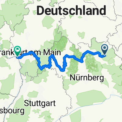
B-BB-Trebgast-Ködnitz-KU
A cycling route starting in Bischofsgrün, Bavaria, Germany.
Overview
About this route
Maintal-BB-Neudorf-Lanzendorf-Himmelkron (Lindenallee Umstellung zwischen Baustelle) -Schlömen-Trebgast-Maintal bis KU >Mainzuzuammenfluss >KU Bus-Bahnhof
- -:--
- Duration
- 51.5 km
- Distance
- 111 m
- Ascent
- 530 m
- Descent
- ---
- Avg. speed
- ---
- Max. altitude
Route quality
Waytypes & surfaces along the route
Waytypes
Path
13.5 km
(26 %)
Quiet road
11.7 km
(23 %)
Surfaces
Paved
31.3 km
(61 %)
Unpaved
4.6 km
(9 %)
Asphalt
30.4 km
(59 %)
Pebblestone
2 km
(4 %)
Route highlights
Points of interest along the route
Point of interest after 43.6 km
Mainzusammenfluß
Continue with Bikemap
Use, edit, or download this cycling route
You would like to ride B-BB-Trebgast-Ködnitz-KU or customize it for your own trip? Here is what you can do with this Bikemap route:
Free features
- Save this route as favorite or in collections
- Copy & plan your own version of this route
- Sync your route with Garmin or Wahoo
Premium features
Free trial for 3 days, or one-time payment. More about Bikemap Premium.
- Navigate this route on iOS & Android
- Export a GPX / KML file of this route
- Create your custom printout (try it for free)
- Download this route for offline navigation
Discover more Premium features.
Get Bikemap PremiumFrom our community
Other popular routes starting in Bischofsgrün
- 2018 Dreigipfeltour
- Distance
- 54.5 km
- Ascent
- 1,465 m
- Descent
- 1,467 m
- Location
- Bischofsgrün, Bavaria, Germany
- 1.Tour Fichtelgebirge
- Distance
- 47.8 km
- Ascent
- 1,066 m
- Descent
- 1,055 m
- Location
- Bischofsgrün, Bavaria, Germany
- Hauptstraße, Bischofsgrün nach Bayreuth
- Distance
- 8.5 km
- Ascent
- 574 m
- Descent
- 237 m
- Location
- Bischofsgrün, Bavaria, Germany
- Saale 1 (Saalequelle-Hirschberg)
- Distance
- 71.4 km
- Ascent
- 488 m
- Descent
- 709 m
- Location
- Bischofsgrün, Bavaria, Germany
- Hauptstraße, Bischofsgrün nach Am Gründlein, Kulmbach
- Distance
- 45.6 km
- Ascent
- 676 m
- Descent
- 1,016 m
- Location
- Bischofsgrün, Bavaria, Germany
- Bischofsgrün, Allemagne / Lichtenfels, Allemagne
- Distance
- 93.1 km
- Ascent
- 243 m
- Descent
- 657 m
- Location
- Bischofsgrün, Bavaria, Germany
- Schneebergauffahrt
- Distance
- 5.4 km
- Ascent
- 382 m
- Descent
- 17 m
- Location
- Bischofsgrün, Bavaria, Germany
- Zwischen Schneeberg u. Ochsenkopf
- Distance
- 17.4 km
- Ascent
- 418 m
- Descent
- 420 m
- Location
- Bischofsgrün, Bavaria, Germany
Open it in the app