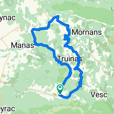
Dieulefit-saou 51k
A cycling route starting in Dieulefit, Auvergne-Rh么ne-Alpes, France.
Overview
About this route
Dieulefit-Saou 51k
- -:--
- Duration
- 51 km
- Distance
- 816 m
- Ascent
- 817 m
- Descent
- ---
- Avg. speed
- ---
- Avg. speed
Route quality
Waytypes & surfaces along the route
Waytypes
Road
39.2 km
(77 %)
Busy road
10.1 km
(20 %)
Surfaces
Paved
12 km
(24 %)
Asphalt
11.8 km
(23 %)
Concrete
0.1 km
(<1 %)
Undefined
39 km
(76 %)
Continue with Bikemap
Use, edit, or download this cycling route
You would like to ride Dieulefit-saou 51k or customize it for your own trip? Here is what you can do with this Bikemap route:
Free features
- Save this route as favorite or in collections
- Copy & plan your own version of this route
- Sync your route with Garmin or Wahoo
Premium features
Free trial for 3 days, or one-time payment. More about Bikemap Premium.
- Navigate this route on iOS & Android
- Export a GPX / KML file of this route
- Create your custom printout (try it for free)
- Download this route for offline navigation
Discover more Premium features.
Get Bikemap PremiumFrom our community
Other popular routes starting in Dieulefit
- 2016 Ride Day 103 - Vesc Circle to Valence
- Distance
- 70.2 km
- Ascent
- 243 m
- Descent
- 670 m
- Location
- Dieulefit, Auvergne-Rh么ne-Alpes, France
- col de valouse
- Distance
- 52.6 km
- Ascent
- 817 m
- Descent
- 813 m
- Location
- Dieulefit, Auvergne-Rh么ne-Alpes, France
- 2014 sainte jalle nord 109 km
- Distance
- 108.7 km
- Ascent
- 1,782 m
- Descent
- 1,803 m
- Location
- Dieulefit, Auvergne-Rh么ne-Alpes, France
- Bourdeaux 1
- Distance
- 62.6 km
- Ascent
- 1,014 m
- Descent
- 1,014 m
- Location
- Dieulefit, Auvergne-Rh么ne-Alpes, France
- 2016 Ride Day 102 - Vesc Circle to St-Nazaire-le-D茅sert
- Distance
- 52.5 km
- Ascent
- 1,048 m
- Descent
- 1,048 m
- Location
- Dieulefit, Auvergne-Rh么ne-Alpes, France
- 2016 Ride Day 99 - Vesc Circle
- Distance
- 40.1 km
- Ascent
- 782 m
- Descent
- 781 m
- Location
- Dieulefit, Auvergne-Rh么ne-Alpes, France
- 53k Dieulefit
- Distance
- 52.3 km
- Ascent
- 821 m
- Descent
- 815 m
- Location
- Dieulefit, Auvergne-Rh么ne-Alpes, France
- Col de la Chaudi猫re
- Distance
- 91.8 km
- Ascent
- 1,616 m
- Descent
- 1,620 m
- Location
- Dieulefit, Auvergne-Rh么ne-Alpes, France
Open it in the app