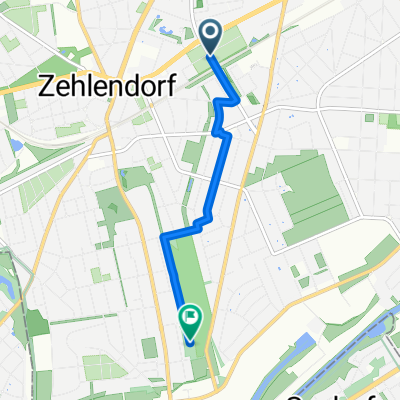
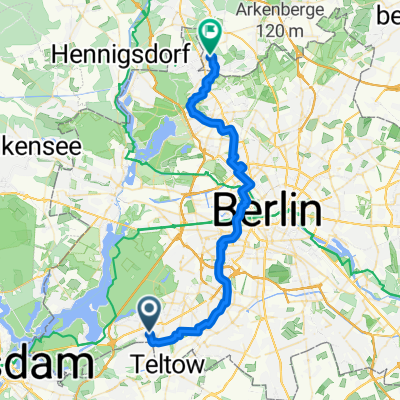
Zehlendorf-Havel-GlienickerBrücke-Mauerweg-Zurück.gpx
A cycling route starting in Zehlendorf, State of Berlin, Germany.
Overview
About this route
TEASI track
- -:--
- Duration
- 31.7 km
- Distance
- 132 m
- Ascent
- 128 m
- Descent
- ---
- Avg. speed
- ---
- Max. altitude
Route quality
Waytypes & surfaces along the route
Waytypes
Path
12.4 km
(39 %)
Quiet road
4.8 km
(15 %)
Surfaces
Paved
15.9 km
(50 %)
Unpaved
13 km
(41 %)
Asphalt
15.6 km
(49 %)
Loose gravel
6.7 km
(21 %)
Continue with Bikemap
Use, edit, or download this cycling route
You would like to ride Zehlendorf-Havel-GlienickerBrücke-Mauerweg-Zurück.gpx or customize it for your own trip? Here is what you can do with this Bikemap route:
Free features
- Save this route as favorite or in collections
- Copy & plan your own version of this route
- Sync your route with Garmin or Wahoo
Premium features
Free trial for 3 days, or one-time payment. More about Bikemap Premium.
- Navigate this route on iOS & Android
- Export a GPX / KML file of this route
- Create your custom printout (try it for free)
- Download this route for offline navigation
Discover more Premium features.
Get Bikemap PremiumFrom our community
Other popular routes starting in Zehlendorf
- Berlin - Dobbrikow - Fläming - Jüterbog - Berlin
- Distance
- 156.8 km
- Ascent
- 378 m
- Descent
- 381 m
- Location
- Zehlendorf, State of Berlin, Germany
- Dobbrikow andersrum
- Distance
- 111.2 km
- Ascent
- 139 m
- Descent
- 133 m
- Location
- Zehlendorf, State of Berlin, Germany
- Zehlendorf -> Fresdorf -> Caputh -> Teufelsberg
- Distance
- 85.4 km
- Ascent
- 298 m
- Descent
- 287 m
- Location
- Zehlendorf, State of Berlin, Germany
- Radtour Südlich von Berlin
- Distance
- 68.2 km
- Ascent
- 117 m
- Descent
- 117 m
- Location
- Zehlendorf, State of Berlin, Germany
- Zehlendorf -> Trebbin
- Distance
- 72.6 km
- Ascent
- 96 m
- Descent
- 95 m
- Location
- Zehlendorf, State of Berlin, Germany
- Grunewaldrund
- Distance
- 25.9 km
- Ascent
- 305 m
- Descent
- 301 m
- Location
- Zehlendorf, State of Berlin, Germany
- grunerunde
- Distance
- 31.4 km
- Ascent
- 181 m
- Descent
- 178 m
- Location
- Zehlendorf, State of Berlin, Germany
- Flache Cross-Runde Berlin-Südwest
- Distance
- 42.1 km
- Ascent
- 114 m
- Descent
- 111 m
- Location
- Zehlendorf, State of Berlin, Germany
Open it in the app