

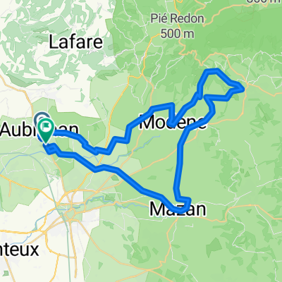
Carpentras
A cycling route starting in Aubignan, Provence-Alpes-Côte d'Azur Region, France.
Overview
About this route
Temp
- -:--
- Duration
- 35.8 km
- Distance
- 8 m
- Ascent
- 0 m
- Descent
- ---
- Avg. speed
- ---
- Max. altitude

Route quality
Waytypes & surfaces along the route
Waytypes
Quiet road
22.9 km
(64 %)
Track
6.8 km
(19 %)
Surfaces
Paved
6.4 km
(18 %)
Unpaved
2.1 km
(6 %)
Asphalt
6.4 km
(18 %)
Gravel
1.4 km
(4 %)
Continue with Bikemap
Use, edit, or download this cycling route
You would like to ride Carpentras or customize it for your own trip? Here is what you can do with this Bikemap route:
Free features
- Save this route as favorite or in collections
- Copy & plan your own version of this route
- Sync your route with Garmin or Wahoo
Premium features
Free trial for 3 days, or one-time payment. More about Bikemap Premium.
- Navigate this route on iOS & Android
- Export a GPX / KML file of this route
- Create your custom printout (try it for free)
- Download this route for offline navigation
Discover more Premium features.
Get Bikemap PremiumFrom our community
Other popular routes starting in Aubignan
 Aubignan Bedoin Ockersteinbrüche 43km
- Distance
- 42.6 km
- Ascent
- 412 m
- Descent
- 411 m
- Location
- Aubignan, Provence-Alpes-Côte d'Azur Region, France
 Mai2015_Aubignan_TourDuVaucluse_Jours1et4
- Distance
- 116 km
- Ascent
- 1,233 m
- Descent
- 1,233 m
- Location
- Aubignan, Provence-Alpes-Côte d'Azur Region, France
 Aubignan Gorges de la Nesque Col des Abeilles
- Distance
- 85.7 km
- Ascent
- 1,954 m
- Descent
- 1,804 m
- Location
- Aubignan, Provence-Alpes-Côte d'Azur Region, France
 Les Gorges du Nesque
- Distance
- 92.6 km
- Ascent
- 1,373 m
- Descent
- 1,383 m
- Location
- Aubignan, Provence-Alpes-Côte d'Azur Region, France
 Maxpulse - TdF - Mont Ventoux
- Distance
- 69 km
- Ascent
- 1,843 m
- Descent
- 1,838 m
- Location
- Aubignan, Provence-Alpes-Côte d'Azur Region, France
 Aubignan-Bedoin-Mt. Ventoux-Malaucene-Le Barroux-Lafare-Aubignan
- Distance
- 77.5 km
- Ascent
- 1,943 m
- Descent
- 1,932 m
- Location
- Aubignan, Provence-Alpes-Côte d'Azur Region, France
 Rit met Rita
- Distance
- 35.4 km
- Ascent
- 131 m
- Descent
- 167 m
- Location
- Aubignan, Provence-Alpes-Côte d'Azur Region, France
 Carpentras
- Distance
- 35.8 km
- Ascent
- 8 m
- Descent
- 0 m
- Location
- Aubignan, Provence-Alpes-Côte d'Azur Region, France
Open it in the app