

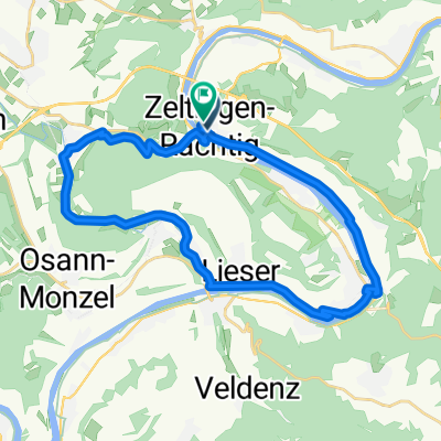
Trier-Koblenz, 2. Etppe
A cycling route starting in Zeltingen-Rachtig, Rhineland-Palatinate, Germany.
Overview
About this route
following the Moselle river to the right or left
- -:--
- Duration
- 85.2 km
- Distance
- 272 m
- Ascent
- 291 m
- Descent
- ---
- Avg. speed
- ---
- Max. altitude

Route quality
Waytypes & surfaces along the route
Waytypes
Path
29.8 km
(35 %)
Track
15.3 km
(18 %)
Surfaces
Paved
65.6 km
(77 %)
Unpaved
5.1 km
(6 %)
Asphalt
63.1 km
(74 %)
Paved (undefined)
2.6 km
(3 %)
Continue with Bikemap
Use, edit, or download this cycling route
You would like to ride Trier-Koblenz, 2. Etppe or customize it for your own trip? Here is what you can do with this Bikemap route:
Free features
- Save this route as favorite or in collections
- Copy & plan your own version of this route
- Split it into stages to create a multi-day tour
- Sync your route with Garmin or Wahoo
Premium features
Free trial for 3 days, or one-time payment. More about Bikemap Premium.
- Navigate this route on iOS & Android
- Export a GPX / KML file of this route
- Create your custom printout (try it for free)
- Download this route for offline navigation
Discover more Premium features.
Get Bikemap PremiumFrom our community
Other popular routes starting in Zeltingen-Rachtig
 tour around Bernkastel Kues
- Distance
- 48 km
- Ascent
- 964 m
- Descent
- 964 m
- Location
- Zeltingen-Rachtig, Rhineland-Palatinate, Germany
 Aktion "Rückenwind"
- Distance
- 32.6 km
- Ascent
- 96 m
- Descent
- 95 m
- Location
- Zeltingen-Rachtig, Rhineland-Palatinate, Germany
 St Florentiner Straße, Zeltingen-Rachtig naar Brückenstraße, Zeltingen-Rachtig
- Distance
- 27.6 km
- Ascent
- 295 m
- Descent
- 297 m
- Location
- Zeltingen-Rachtig, Rhineland-Palatinate, Germany
 Trier-Koblenz, 2. Etppe
- Distance
- 85.2 km
- Ascent
- 272 m
- Descent
- 291 m
- Location
- Zeltingen-Rachtig, Rhineland-Palatinate, Germany
 Stage 1
- Distance
- 39.2 km
- Ascent
- 286 m
- Descent
- 264 m
- Location
- Zeltingen-Rachtig, Rhineland-Palatinate, Germany
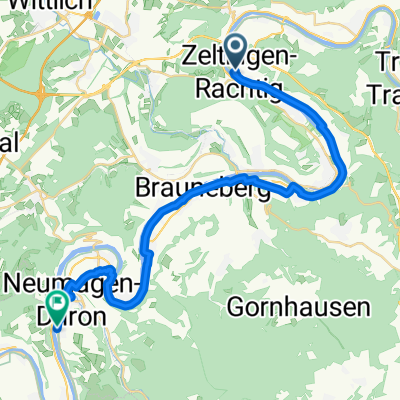 St Florentiner Straße, Zeltingen-Rachtig naar Burgstraße, Neumagen-Dhron
- Distance
- 30.6 km
- Ascent
- 306 m
- Descent
- 300 m
- Location
- Zeltingen-Rachtig, Rhineland-Palatinate, Germany
 Saar Mosel Tag 4 Zeltingen-Rachting - Bremm
- Distance
- 46.3 km
- Ascent
- 192 m
- Descent
- 199 m
- Location
- Zeltingen-Rachtig, Rhineland-Palatinate, Germany
 Whelen Rhaunen
- Distance
- 108.5 km
- Ascent
- 1,100 m
- Descent
- 1,101 m
- Location
- Zeltingen-Rachtig, Rhineland-Palatinate, Germany
Open it in the app