
Tur po Sloveniji I
A cycling route starting in Poljčane, Občina Poljčane, Slovenia.
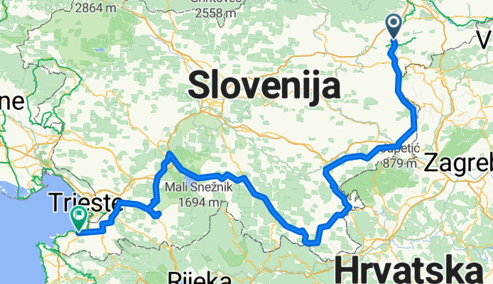
Overview
About this route
Tudi letošnja etapa je bila v znamenju Abrahamovca Brankota, ki jo je organiziral , ki pa še ni zaključena, saj naj bi celotna etapa potekala po obsegu Slovenije
<span class="ms">25.04.2009 - prva etapa. Start ob 06.30 izpred bara Pušnik, prihod v Kočevje ob 19.00. Prevoženih 190Km </span>
<span class="ms">
<br />26.04.2009 - druga etapa. Start ob 08.45 iz Kočevja, prihod na Ratečevo Brdo ob 17.00. Prevoženih 109Km<br />
27.04.2009 - tretja etapa. Start ob 08.30 iz Ratečevega Brda, prihod v Koper ob 10.47 uri. Prevoženih 74Km
Vse dni na turi smo imeli prijetno sončno vreme. </span>
- -:--
- Duration
- 355.2 km
- Distance
- 3,896 m
- Ascent
- 3,885 m
- Descent
- ---
- Avg. speed
- 784 m
- Max. altitude

Route quality
Waytypes & surfaces along the route
Waytypes
Quiet road
35.5 km
(10 %)
Road
32 km
(9 %)
Surfaces
Paved
202.5 km
(57 %)
Unpaved
3.6 km
(1 %)
Asphalt
202.5 km
(57 %)
Gravel
3.6 km
(1 %)
Undefined
149.2 km
(42 %)
Route highlights
Points of interest along the route
Point of interest after 294.9 km
cilj 3.etape po 109Km s prihodom na Ratečevo Brdo. start 3.etape naslednje jutro
Continue with Bikemap
Use, edit, or download this cycling route
You would like to ride Tur po Sloveniji I or customize it for your own trip? Here is what you can do with this Bikemap route:
Free features
- Save this route as favorite or in collections
- Copy & plan your own version of this route
- Split it into stages to create a multi-day tour
- Sync your route with Garmin or Wahoo
Premium features
Free trial for 3 days, or one-time payment. More about Bikemap Premium.
- Navigate this route on iOS & Android
- Export a GPX / KML file of this route
- Create your custom printout (try it for free)
- Download this route for offline navigation
Discover more Premium features.
Get Bikemap PremiumFrom our community
Other popular routes starting in Poljčane
 MTB: Poljčane - Boč - Poljčane
- Distance
- 18.7 km
- Ascent
- 842 m
- Descent
- 842 m
- Location
- Poljčane, Občina Poljčane, Slovenia
 MTB: Poljčane - Boč (Stolp)
- Distance
- 26.2 km
- Ascent
- 934 m
- Descent
- 938 m
- Location
- Poljčane, Občina Poljčane, Slovenia
 Okoli Boča
- Distance
- 23.1 km
- Ascent
- 932 m
- Descent
- 936 m
- Location
- Poljčane, Občina Poljčane, Slovenia
 Tur po Sloveniji I
- Distance
- 355.2 km
- Ascent
- 3,896 m
- Descent
- 3,885 m
- Location
- Poljčane, Občina Poljčane, Slovenia
 STKP 27: Planinski dom na Boču – Gorišnica
- Distance
- 60.8 km
- Ascent
- 903 m
- Descent
- 1,353 m
- Location
- Poljčane, Občina Poljčane, Slovenia
 čez Boč
- Distance
- 31.3 km
- Ascent
- 688 m
- Descent
- 691 m
- Location
- Poljčane, Občina Poljčane, Slovenia
 Poljčane- Boč- Donačk g.- Poljčane
- Distance
- 45.9 km
- Ascent
- 1,892 m
- Descent
- 1,926 m
- Location
- Poljčane, Občina Poljčane, Slovenia
 Sp.Brežnica-Pečica-Šmarje-Šentjur-Ponikva-Mlače-Poljčane
- Distance
- 52.7 km
- Ascent
- 707 m
- Descent
- 710 m
- Location
- Poljčane, Občina Poljčane, Slovenia
Open it in the app