

Wasser, Wald und Wackerstein
A cycling route starting in Bad Liebenwerda, Brandenburg, Germany.
Overview
About this route
In a wide arc, the ‚Schwarze Elster‘ embraces the Niederlausitzer Heidelandschaft Nature Park in the south and west. Until the mid-19th century, it still consisted of a dense network of river arms and islands. In 1852, under pressure from the farmers, the law for the improvement of the Schwarze Elster lowlands was passed. Today, hardly anything remains of the former river arms and diverse vegetation. A first step to hold water longer in the region, has meanwhile been implemented with the project to renature the Kleine Elster.
Much earlier, with the establishment of the Dobrilugk monastery, the surrounding forests were gradually reduced in size. The main tree species on the poor soils is the pine. However, there are also special features such as the silver fir or the Niederlausitzer lowland spruce. But there is also something very special to see on the tour. About 15 metres above, the Rothsteiner Rock towers over the surrounding landscape. Romantic hideaways and paths, steep slopes as well as sharp ridges – high mountains in miniature! The rock is only the tip of an underground mountain range, whose foothills extend to Torgau, among other places. The Rothsteiner Rock is a geological natural monument and this rock composition is only found three more times – in Yellowstone National Park, in New Zealand and in Iceland.- -:--
- Duration
- 36.3 km
- Distance
- 116 m
- Ascent
- 116 m
- Descent
- ---
- Avg. speed
- ---
- Max. altitude
Route quality
Waytypes & surfaces along the route
Waytypes
Track
8.7 km
(24 %)
Quiet road
8 km
(22 %)
Surfaces
Paved
31.2 km
(86 %)
Unpaved
2.5 km
(7 %)
Asphalt
30.1 km
(83 %)
Gravel
1.8 km
(5 %)
Continue with Bikemap
Use, edit, or download this cycling route
You would like to ride Wasser, Wald und Wackerstein or customize it for your own trip? Here is what you can do with this Bikemap route:
Free features
- Save this route as favorite or in collections
- Copy & plan your own version of this route
- Sync your route with Garmin or Wahoo
Premium features
Free trial for 3 days, or one-time payment. More about Bikemap Premium.
- Navigate this route on iOS & Android
- Export a GPX / KML file of this route
- Create your custom printout (try it for free)
- Download this route for offline navigation
Discover more Premium features.
Get Bikemap PremiumFrom our community
Other popular routes starting in Bad Liebenwerda
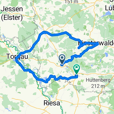
 Wasser, Wald und Wackerstein
- Distance
- 36.3 km
- Ascent
- 116 m
- Descent
- 116 m
- Location
- Bad Liebenwerda, Brandenburg, Germany
 Auf den Spuren der Mönche von Dobrilugk
- Distance
- 107.4 km
- Ascent
- 143 m
- Descent
- 145 m
- Location
- Bad Liebenwerda, Brandenburg, Germany
 50Km Liebenwerda Doberlugk Tröbitz, Rundfahrt
- Distance
- 50 km
- Ascent
- 142 m
- Descent
- 143 m
- Location
- Bad Liebenwerda, Brandenburg, Germany
 Von Bad Liebenwerda nach Forst
- Distance
- 115 km
- Ascent
- 188 m
- Descent
- 200 m
- Location
- Bad Liebenwerda, Brandenburg, Germany
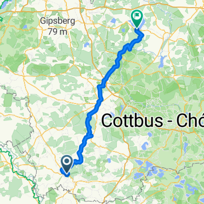
 2.Tag, Bad Liebenwerda- Cottbus
- Distance
- 103.8 km
- Ascent
- 214 m
- Descent
- 223 m
- Location
- Bad Liebenwerda, Brandenburg, Germany
 Chemnitz-Usedom; 2.Etappe
- Distance
- 126.9 km
- Ascent
- 149 m
- Descent
- 203 m
- Location
- Bad Liebenwerda, Brandenburg, Germany
 25 Jahre SUN-SPORT-TEAM die Kurze
- Distance
- 156.3 km
- Ascent
- 166 m
- Descent
- 165 m
- Location
- Bad Liebenwerda, Brandenburg, Germany
 Day 3
Day 3- Distance
- 144.7 km
- Ascent
- 253 m
- Descent
- 313 m
- Location
- Bad Liebenwerda, Brandenburg, Germany
Open it in the app