
Von Kalteneck nach Ingling
A cycling route starting in Hutthurm, Bavaria, Germany.
Overview
About this route
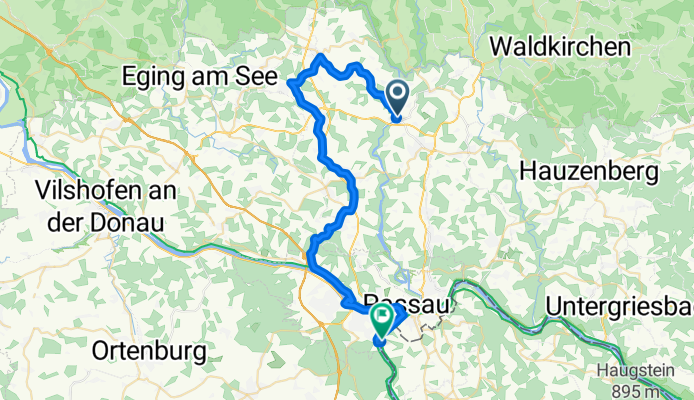
Mit der Ilztalbahn vom Bahnhof Passau nach Kalteneck, hier gehts über die Ilzbrücke und rechts auf den Donau-Ilzradweg bis nach Tittling wo man links auf den Donau-Böhmerwaldradweg einbiegt. Diesen radelt man entlang bis zur Gaissamündung in die Donau, links gehts weiter auf dem Donauradweg zurück nach Passau, entlang des Inns bis Ingling.
- -:--
- Duration
- 40.7 km
- Distance
- 333 m
- Ascent
- 364 m
- Descent
- ---
- Avg. speed
- ---
- Max. altitude
Route quality
Waytypes & surfaces along the route
Waytypes
Quiet road
10.8 km
(27 %)
Path
10.5 km
(26 %)
Surfaces
Paved
20 km
(49 %)
Unpaved
11 km
(27 %)
Asphalt
19.9 km
(49 %)
Unpaved (undefined)
7.9 km
(19 %)
Continue with Bikemap
Use, edit, or download this cycling route
You would like to ride Von Kalteneck nach Ingling or customize it for your own trip? Here is what you can do with this Bikemap route:
Free features
- Save this route as favorite or in collections
- Copy & plan your own version of this route
- Sync your route with Garmin or Wahoo
Premium features
Free trial for 3 days, or one-time payment. More about Bikemap Premium.
- Navigate this route on iOS & Android
- Export a GPX / KML file of this route
- Create your custom printout (try it for free)
- Download this route for offline navigation
Discover more Premium features.
Get Bikemap PremiumFrom our community
Other popular routes starting in Hutthurm
 Unterer Markt 15, Hutthurm nach Schönbrunn am Lusen 531, Hohenau
- Distance
- 34 km
- Ascent
- 975 m
- Descent
- 698 m
- Location
- Hutthurm, Bavaria, Germany
 Kalteneck-Schrottenbaumühle
- Distance
- 12.9 km
- Ascent
- 143 m
- Descent
- 124 m
- Location
- Hutthurm, Bavaria, Germany
 2013 Ilz Runde
- Distance
- 13 km
- Ascent
- 342 m
- Descent
- 332 m
- Location
- Hutthurm, Bavaria, Germany
 Kaltenstein-Tour
- Distance
- 32.5 km
- Ascent
- 522 m
- Descent
- 523 m
- Location
- Hutthurm, Bavaria, Germany
 Lichtenauer-Tour III
- Distance
- 30.9 km
- Ascent
- 603 m
- Descent
- 608 m
- Location
- Hutthurm, Bavaria, Germany
 Donau Ilz radweg
- Distance
- 87.1 km
- Ascent
- 319 m
- Descent
- 356 m
- Location
- Hutthurm, Bavaria, Germany
 Tina
Tina- Distance
- 13 km
- Ascent
- 127 m
- Descent
- 311 m
- Location
- Hutthurm, Bavaria, Germany
 Bayerwaldroute
- Distance
- 98.9 km
- Ascent
- 1,460 m
- Descent
- 1,343 m
- Location
- Hutthurm, Bavaria, Germany
Open it in the app