
Francigena-Capranica-Sutri-Parco Archeologico
A cycling route starting in Bassano Romano, Lazio, Italy.
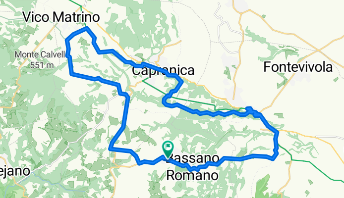
Overview
About this route
From B&B la Rocca, you reach Capranica Scalo and, through the Canaglia road, intercept the Francigena, which you follow until Capranica and then Sutri. Return via the Prataiola road or Valle Petrana.
- -:--
- Duration
- 32.2 km
- Distance
- 320 m
- Ascent
- 325 m
- Descent
- ---
- Avg. speed
- ---
- Max. altitude
Route quality
Waytypes & surfaces along the route
Waytypes
Track
13.2 km
(41 %)
Quiet road
7.1 km
(22 %)
Surfaces
Paved
9.3 km
(29 %)
Unpaved
15.5 km
(48 %)
Asphalt
9.3 km
(29 %)
Gravel
8.7 km
(27 %)
Route highlights
Points of interest along the route

Point of interest after 0.1 km
B&B La Rocca
Continue with Bikemap
Use, edit, or download this cycling route
You would like to ride Francigena-Capranica-Sutri-Parco Archeologico or customize it for your own trip? Here is what you can do with this Bikemap route:
Free features
- Save this route as favorite or in collections
- Copy & plan your own version of this route
- Sync your route with Garmin or Wahoo
Premium features
Free trial for 3 days, or one-time payment. More about Bikemap Premium.
- Navigate this route on iOS & Android
- Export a GPX / KML file of this route
- Create your custom printout (try it for free)
- Download this route for offline navigation
Discover more Premium features.
Get Bikemap PremiumFrom our community
Other popular routes starting in Bassano Romano
 Francigena Capranica-Sutri
- Distance
- 31.1 km
- Ascent
- 327 m
- Descent
- 327 m
- Location
- Bassano Romano, Lazio, Italy
 Lago di Vico
- Distance
- 47.2 km
- Ascent
- 578 m
- Descent
- 585 m
- Location
- Bassano Romano, Lazio, Italy
 Francigena-Capranica-Sutri-Parco Archeologico
- Distance
- 32.2 km
- Ascent
- 320 m
- Descent
- 325 m
- Location
- Bassano Romano, Lazio, Italy
 Vecchia Ferrovia-Parco Marturanum-Necropoli S. Giovenale
- Distance
- 56.4 km
- Ascent
- 553 m
- Descent
- 553 m
- Location
- Bassano Romano, Lazio, Italy
 june 16
- Distance
- 62.1 km
- Ascent
- 334 m
- Descent
- 800 m
- Location
- Bassano Romano, Lazio, Italy
 Lago di Vico - 2
- Distance
- 48.8 km
- Ascent
- 520 m
- Descent
- 526 m
- Location
- Bassano Romano, Lazio, Italy
 Parco Naturale del Lago di Bracciano e Sentiero Malpasso
- Distance
- 34.8 km
- Ascent
- 709 m
- Descent
- 715 m
- Location
- Bassano Romano, Lazio, Italy
 Bassano-Soriano
- Distance
- 64.6 km
- Ascent
- 1,021 m
- Descent
- 1,006 m
- Location
- Bassano Romano, Lazio, Italy
Open it in the app