

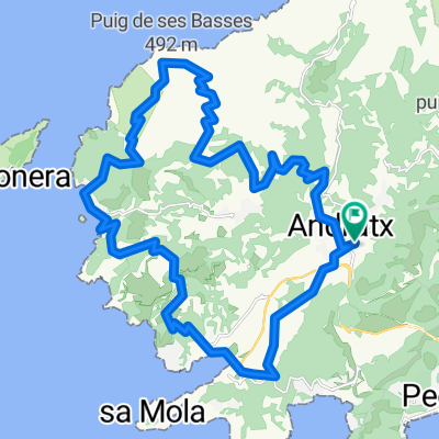
Sierra de So na Vidala -20150913_102644.gpx
A cycling route starting in Andratx, Balearic Islands, Spain.
Overview
About this route
TEASI track
- -:--
- Duration
- 14.4 km
- Distance
- 615 m
- Ascent
- 600 m
- Descent
- ---
- Avg. speed
- ---
- Max. altitude

Route highlights
Points of interest along the route

Photo after 5.3 km

Photo after 8.3 km
Continue with Bikemap
Use, edit, or download this cycling route
You would like to ride Sierra de So na Vidala -20150913_102644.gpx or customize it for your own trip? Here is what you can do with this Bikemap route:
Free features
- Save this route as favorite or in collections
- Copy & plan your own version of this route
- Sync your route with Garmin or Wahoo
Premium features
Free trial for 3 days, or one-time payment. More about Bikemap Premium.
- Navigate this route on iOS & Android
- Export a GPX / KML file of this route
- Create your custom printout (try it for free)
- Download this route for offline navigation
Discover more Premium features.
Get Bikemap PremiumFrom our community
Other popular routes starting in Andratx
 Mallorca a peu: puig d'en Farineta
- Distance
- 3.1 km
- Ascent
- 188 m
- Descent
- 188 m
- Location
- Andratx, Balearic Islands, Spain
 Andratx-La_Trapa_pMAPA DE CALOR
- Distance
- 36.5 km
- Ascent
- 1,008 m
- Descent
- 1,008 m
- Location
- Andratx, Balearic Islands, Spain
 Sierra de So na Vidala -20150913_102644.gpx
- Distance
- 14.4 km
- Ascent
- 615 m
- Descent
- 600 m
- Location
- Andratx, Balearic Islands, Spain
 Route in Andratx
- Distance
- 62.8 km
- Ascent
- 3,374 m
- Descent
- 3,385 m
- Location
- Andratx, Balearic Islands, Spain
 M: Coast Classic
- Distance
- 120.5 km
- Ascent
- 1,903 m
- Descent
- 1,962 m
- Location
- Andratx, Balearic Islands, Spain
 Mallorca Day 13 Sant Elm to Palma
- Distance
- 49.2 km
- Ascent
- 956 m
- Descent
- 950 m
- Location
- Andratx, Balearic Islands, Spain
 Küstenklassiker
- Distance
- 123.5 km
- Ascent
- 4,780 m
- Descent
- 4,830 m
- Location
- Andratx, Balearic Islands, Spain
 Mallorca 1.Mai
- Distance
- 63.1 km
- Ascent
- 1,191 m
- Descent
- 1,194 m
- Location
- Andratx, Balearic Islands, Spain
Open it in the app