
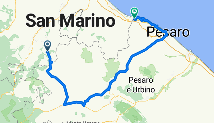
Villagrande - Gabicce Mare
A cycling route starting in Villagrande, The Marches, Italy.
Overview
About this route
Transfer from Valverde di Cesenatico to Villagrande. Through Urbino in the Marche region to Gabicce Monte. From Villagrande, the first 38 km are downhill, interrupted by some intermediate climbs. On the SP 6 and SP 18 to Frontino. Further on the SP Mutino to SS 687 at Lunano. Then on to Sant'Angelo in Vado. Left onto the SS 73 towards Urbania. Continue on the SS 73 to Urbino. First on the SP 423 towards Pesaro to Morciola. There, right onto the SP 30 over Montelabbate and Villa Fastiggi to Pesaro. On the SP 44 (signs for coastal road) through the Parco Naturale del Monte San Bartolo to Gabicce Monte. After Pesaro, about 150 m of elevation gain must be overcome. The subsequent coastal road then offers views of the Adriatic. Descent to Gabicce Mare. Return transfer to Valverde di Cesenatico.
- -:--
- Duration
- 118.9 km
- Distance
- 694 m
- Ascent
- 1,666 m
- Descent
- ---
- Avg. speed
- ---
- Max. altitude

Route quality
Waytypes & surfaces along the route
Waytypes
Road
22.6 km
(19 %)
Quiet road
9.5 km
(8 %)
Surfaces
Paved
70.2 km
(59 %)
Asphalt
70.2 km
(59 %)
Undefined
48.7 km
(41 %)
Continue with Bikemap
Use, edit, or download this cycling route
You would like to ride Villagrande - Gabicce Mare or customize it for your own trip? Here is what you can do with this Bikemap route:
Free features
- Save this route as favorite or in collections
- Copy & plan your own version of this route
- Split it into stages to create a multi-day tour
- Sync your route with Garmin or Wahoo
Premium features
Free trial for 3 days, or one-time payment. More about Bikemap Premium.
- Navigate this route on iOS & Android
- Export a GPX / KML file of this route
- Create your custom printout (try it for free)
- Download this route for offline navigation
Discover more Premium features.
Get Bikemap PremiumFrom our community
Other popular routes starting in Villagrande
 Villagrande - Gabicce Mare
- Distance
- 118.9 km
- Ascent
- 694 m
- Descent
- 1,666 m
- Location
- Villagrande, The Marches, Italy
 giro sabato
- Distance
- 40.1 km
- Ascent
- 1,392 m
- Descent
- 1,393 m
- Location
- Villagrande, The Marches, Italy
 rifugio passo trabocchetto
- Distance
- 7.5 km
- Ascent
- 223 m
- Descent
- 566 m
- Location
- Villagrande, The Marches, Italy
 Calvillano/Calvillano da PC
- Distance
- 5.9 km
- Ascent
- 306 m
- Descent
- 302 m
- Location
- Villagrande, The Marches, Italy
 villagrande monte piatracandella
- Distance
- 4.2 km
- Ascent
- 379 m
- Descent
- 32 m
- Location
- Villagrande, The Marches, Italy
 SP 6, Montecopiolo a Strada di San Michele, Borgo Maggiore
- Distance
- 34.5 km
- Ascent
- 699 m
- Descent
- 1,132 m
- Location
- Villagrande, The Marches, Italy
 3. Montecopiolo - numana
- Distance
- 202.2 km
- Ascent
- 689 m
- Descent
- 1,580 m
- Location
- Villagrande, The Marches, Italy
 San Leo
- Distance
- 21.7 km
- Ascent
- 224 m
- Descent
- 752 m
- Location
- Villagrande, The Marches, Italy
Open it in the app