

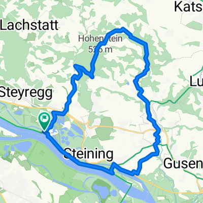
MTB Runde 20km - Pürach - Götzelsdorf - Haid - Wolfing - Hohenstein - Weingraben - St. Georgen
A cycling route starting in Steyregg, Upper Austria, Austria.
Overview
About this route
Diese Ründe ist eher für MTB Einsteiger geeignet welche am Aufbau Ihrer Kondition arbeiten. Die Strecke führt über einige Straßenwege nach Pürach. Durch den Wald geht es hinab nach Pulgarn (Offroad). Von dort geht es auf Wald- und Wiesenwegen entlang dem Donausteig bis Götzelsdorf. Über Straßenwege geht es aufwärts bis nach Haid und weiter über Wolfing bis Hohenstein. Vorbai am Aigidi Kircherl geht es im Wald hinunter in den Weingraben. Weiter auf dem Straßenweg bis St. Georgen und über einen Schotterweg aufwärts nach Statzing. Angaben zur Route (1 = leicht, 10 = schwer) Kondition: 2-3 Technik: 3-4 Abwechslung: 5
(cloned from route 2313305)
- -:--
- Duration
- 20.5 km
- Distance
- 353 m
- Ascent
- 353 m
- Descent
- ---
- Avg. speed
- ---
- Max. altitude
Route quality
Waytypes & surfaces along the route
Waytypes
Quiet road
11.6 km
(56 %)
Track
7.3 km
(36 %)
Surfaces
Paved
3.3 km
(16 %)
Unpaved
5.8 km
(28 %)
Ground
3.8 km
(19 %)
Asphalt
3.3 km
(16 %)
Continue with Bikemap
Use, edit, or download this cycling route
You would like to ride MTB Runde 20km - Pürach - Götzelsdorf - Haid - Wolfing - Hohenstein - Weingraben - St. Georgen or customize it for your own trip? Here is what you can do with this Bikemap route:
Free features
- Save this route as favorite or in collections
- Copy & plan your own version of this route
- Sync your route with Garmin or Wahoo
Premium features
Free trial for 3 days, or one-time payment. More about Bikemap Premium.
- Navigate this route on iOS & Android
- Export a GPX / KML file of this route
- Create your custom printout (try it for free)
- Download this route for offline navigation
Discover more Premium features.
Get Bikemap PremiumFrom our community
Other popular routes starting in Steyregg
 Mountainbike SolarCity - GIS (Giselawarte)
- Distance
- 27.3 km
- Ascent
- 778 m
- Descent
- 101 m
- Location
- Steyregg, Upper Austria, Austria
 MTB Runde 45km - Statzing
- Distance
- 45.3 km
- Ascent
- 952 m
- Descent
- 952 m
- Location
- Steyregg, Upper Austria, Austria
 MTB Runde 30km
- Distance
- 30.5 km
- Ascent
- 521 m
- Descent
- 521 m
- Location
- Steyregg, Upper Austria, Austria
 Linz-Königswiesen-Grein-Linz
- Distance
- 151.6 km
- Ascent
- 935 m
- Descent
- 923 m
- Location
- Steyregg, Upper Austria, Austria
 Hohenstein
- Distance
- 21.5 km
- Ascent
- 306 m
- Descent
- 308 m
- Location
- Steyregg, Upper Austria, Austria
 MTB Runde 55km - Satzing - Pürach - Götzelsdorf - Holzwinden - Lachstadt - Pfenningberg - Plesching - Linz-Urfahr - Lichtenberg - GIS Warte - Lichtenberg - Linz
- Distance
- 55.7 km
- Ascent
- 1,295 m
- Descent
- 1,297 m
- Location
- Steyregg, Upper Austria, Austria
 Linz-Gramastetten-Kirchaschlag-Goli-Linz
- Distance
- 70.8 km
- Ascent
- 1,424 m
- Descent
- 1,424 m
- Location
- Steyregg, Upper Austria, Austria
 Südlicher Pfenningberg
- Distance
- 8.9 km
- Ascent
- 416 m
- Descent
- 300 m
- Location
- Steyregg, Upper Austria, Austria
Open it in the app