

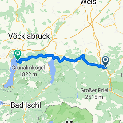
20150912_115524.gpx
A cycling route starting in Micheldorf in Oberösterreich, Upper Austria, Austria.
Overview
About this route
TEASI track
- -:--
- Duration
- 12.5 km
- Distance
- 150 m
- Ascent
- 221 m
- Descent
- ---
- Avg. speed
- ---
- Max. altitude
Continue with Bikemap
Use, edit, or download this cycling route
You would like to ride 20150912_115524.gpx or customize it for your own trip? Here is what you can do with this Bikemap route:
Free features
- Save this route as favorite or in collections
- Copy & plan your own version of this route
- Sync your route with Garmin or Wahoo
Premium features
Free trial for 3 days, or one-time payment. More about Bikemap Premium.
- Navigate this route on iOS & Android
- Export a GPX / KML file of this route
- Create your custom printout (try it for free)
- Download this route for offline navigation
Discover more Premium features.
Get Bikemap PremiumFrom our community
Other popular routes starting in Micheldorf in Oberösterreich
 2025_08_18_Micheldorf-Weyregg
- Distance
- 66.8 km
- Ascent
- 1,770 m
- Descent
- 1,754 m
- Location
- Micheldorf in Oberösterreich, Upper Austria, Austria
 2025_Micheldorf-Scharnstein
- Distance
- 54.6 km
- Ascent
- 2,176 m
- Descent
- 2,176 m
- Location
- Micheldorf in Oberösterreich, Upper Austria, Austria
 OBK Jagahäusl
- Distance
- 45.5 km
- Ascent
- 716 m
- Descent
- 734 m
- Location
- Micheldorf in Oberösterreich, Upper Austria, Austria
 Tour de Croatia 2 Klauser See-Trieben
- Distance
- 68 km
- Ascent
- 1,297 m
- Descent
- 1,093 m
- Location
- Micheldorf in Oberösterreich, Upper Austria, Austria
 Hochbaumgarten - Haindlmühle-Graben - Hochbaumgarten
- Distance
- 16.2 km
- Ascent
- 502 m
- Descent
- 493 m
- Location
- Micheldorf in Oberösterreich, Upper Austria, Austria
 zum See über Klaus am Radweg
- Distance
- 19.2 km
- Ascent
- 185 m
- Descent
- 177 m
- Location
- Micheldorf in Oberösterreich, Upper Austria, Austria
 Von Klaus an der Pyhrnbahn bis Rosenau am Hengstpaß
- Distance
- 33.1 km
- Ascent
- 1,053 m
- Descent
- 756 m
- Location
- Micheldorf in Oberösterreich, Upper Austria, Austria
 2025_04_29_Micheldorf- Hochberghaus-Micheldorf
- Distance
- 75.1 km
- Ascent
- 1,885 m
- Descent
- 1,886 m
- Location
- Micheldorf in Oberösterreich, Upper Austria, Austria
Open it in the app