

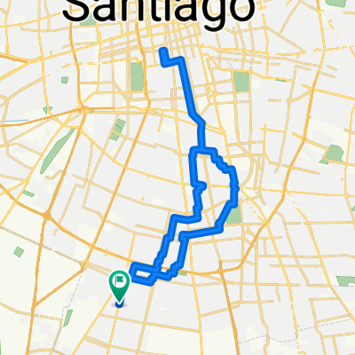
Ciclovía Vicuña Mackenna - Concha y Toro
A cycling route starting in La Pintana, Santiago Metropolitan, Chile.
Overview
About this route
Use with caution, it is not continuous and follows various designs, sometimes the proper width, other times just a narrow stripe.
- -:--
- Duration
- 8.9 km
- Distance
- 83 m
- Ascent
- 0 m
- Descent
- ---
- Avg. speed
- ---
- Max. altitude

Route quality
Waytypes & surfaces along the route
Waytypes
Cycleway
8.2 km
(92 %)
Quiet road
0.3 km
(3 %)
Surfaces
Paved
4.6 km
(51 %)
Paved (undefined)
2.9 km
(32 %)
Asphalt
1.2 km
(13 %)
Continue with Bikemap
Use, edit, or download this cycling route
You would like to ride Ciclovía Vicuña Mackenna - Concha y Toro or customize it for your own trip? Here is what you can do with this Bikemap route:
Free features
- Save this route as favorite or in collections
- Copy & plan your own version of this route
- Sync your route with Garmin or Wahoo
Premium features
Free trial for 3 days, or one-time payment. More about Bikemap Premium.
- Navigate this route on iOS & Android
- Export a GPX / KML file of this route
- Create your custom printout (try it for free)
- Download this route for offline navigation
Discover more Premium features.
Get Bikemap PremiumFrom our community
Other popular routes starting in La Pintana
 LA CISTERNA A CALLEJONES
- Distance
- 63.9 km
- Ascent
- 146 m
- Descent
- 240 m
- Location
- La Pintana, Santiago Metropolitan, Chile
 Quebrada Macul
- Distance
- 46.6 km
- Ascent
- 559 m
- Descent
- 539 m
- Location
- La Pintana, Santiago Metropolitan, Chile
 La Pintana - Isla de maipo - La pintana
- Distance
- 93.5 km
- Ascent
- 531 m
- Descent
- 559 m
- Location
- La Pintana, Santiago Metropolitan, Chile
 AL CAMPAMENTO DE VERANO
- Distance
- 33 km
- Ascent
- 397 m
- Descent
- 58 m
- Location
- La Pintana, Santiago Metropolitan, Chile
 RUTA A OXFORD
- Distance
- 18.4 km
- Ascent
- 31 m
- Descent
- 99 m
- Location
- La Pintana, Santiago Metropolitan, Chile
 cerro panul
- Distance
- 12.9 km
- Ascent
- 221 m
- Descent
- 9 m
- Location
- La Pintana, Santiago Metropolitan, Chile
 De Los Patos a Los Patos
- Distance
- 36.2 km
- Ascent
- 90 m
- Descent
- 92 m
- Location
- La Pintana, Santiago Metropolitan, Chile
 La Pintana - Rio Clarillo - La pintana
- Distance
- 71.6 km
- Ascent
- 901 m
- Descent
- 855 m
- Location
- La Pintana, Santiago Metropolitan, Chile
Open it in the app