

Einführungstour 2011
A cycling route starting in Grunewald, State of Berlin, Germany.
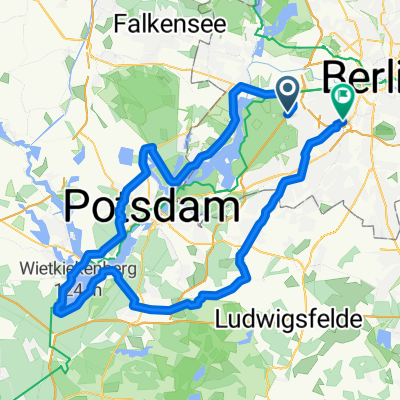
Overview
About this route
Start at Schmetterlingsplatz - located on the Grunewald side of Grunewald train station.
Almost all streets are very quiet, and there are also
(almost) car-free zones
Königsweg / Kronprinzessinnenweg (km 0.5 - 6.5)
Genshagen industrial area (km 54.5 - 59)
good cycling paths
Großbeeren - Jühnsdorf (km 30 - 40)
Groß Schulzendorf - Kerzendorf (km 45 - 50.5 - only outside towns)
Neubeeren - Ruhlsdorf ( km 63 - 65)
(as a larger group, we are unlikely to use these)
unpleasant streets
Stahnsdorf - Güterfelde (~3 km, narrow road outside the city, side winds - but currently much calmer due to construction work)
L794 towards Neubeeren (some cars drive far too fast - but it is only 1.5 km and we should have a tailwind)
Ruhlsdorf - Teltow (sometimes busy, 4 km)
- -:--
- Duration
- 79.3 km
- Distance
- 92 m
- Ascent
- 97 m
- Descent
- ---
- Avg. speed
- ---
- Max. altitude

Route quality
Waytypes & surfaces along the route
Waytypes
Path
16.6 km
(21 %)
Road
15.9 km
(20 %)
Surfaces
Paved
69 km
(87 %)
Unpaved
1.6 km
(2 %)
Asphalt
68.2 km
(86 %)
Ground
1.6 km
(2 %)
Route highlights
Points of interest along the route
Point of interest after 0.4 km
ab hier autofrei
Point of interest after 6.6 km
Ende der autofreien Strecke
Point of interest after 25.7 km
ab hier 1,5 km unangenehm
Point of interest after 35.7 km
Pause & Treffen mit der Gruppe aus Treptow - http://www.schlossdiedersdorf.de/
Point of interest after 56.5 km
McDonald's & Tankstelle - ab hier ruhiges Industriegebiet
Point of interest after 59.4 km
ab hier durch ein nie fertig gewordenes Industriegebiet - die Straßen sind für Autos gesperrt
Point of interest after 60.7 km
ab hier wieder Autoverkehr, allerdings sehr, sehr wenig
Point of interest after 64.3 km
von hier bis Teltow, Ruhlsdorfer Platz, manchmal unangenehm viel Verkehr (~ 6 km), auf den ersten 2 km gibt's einen guten Radweg
Continue with Bikemap
Use, edit, or download this cycling route
You would like to ride Einführungstour 2011 or customize it for your own trip? Here is what you can do with this Bikemap route:
Free features
- Save this route as favorite or in collections
- Copy & plan your own version of this route
- Sync your route with Garmin or Wahoo
Premium features
Free trial for 3 days, or one-time payment. More about Bikemap Premium.
- Navigate this route on iOS & Android
- Export a GPX / KML file of this route
- Create your custom printout (try it for free)
- Download this route for offline navigation
Discover more Premium features.
Get Bikemap PremiumFrom our community
Other popular routes starting in Grunewald
 Schwielowsee-Feierabendrunde finalisiert
- Distance
- 89.9 km
- Ascent
- 303 m
- Descent
- 303 m
- Location
- Grunewald, State of Berlin, Germany
 Große Potsdamer Runde
- Distance
- 91.1 km
- Ascent
- 251 m
- Descent
- 254 m
- Location
- Grunewald, State of Berlin, Germany
 perm Wildenbruch
- Distance
- 77.1 km
- Ascent
- 230 m
- Descent
- 229 m
- Location
- Grunewald, State of Berlin, Germany
 S Grunewald, Caputh, Schenkenhorst, S Grunewald (ohne Havelchaussee)
- Distance
- 76.8 km
- Ascent
- 320 m
- Descent
- 318 m
- Location
- Grunewald, State of Berlin, Germany
 Havelrunde
- Distance
- 20.9 km
- Ascent
- 103 m
- Descent
- 107 m
- Location
- Grunewald, State of Berlin, Germany
 Schwielowsee-Feierabendrunde
- Distance
- 83.8 km
- Ascent
- 349 m
- Descent
- 346 m
- Location
- Grunewald, State of Berlin, Germany
 Spandau, Sacrow, Schwielowsee, Caputh, Schenkenhorst
- Distance
- 94.7 km
- Ascent
- 390 m
- Descent
- 395 m
- Location
- Grunewald, State of Berlin, Germany
 RTF Havel-Frühlingsrunde 2 Pkt.
- Distance
- 80.2 km
- Ascent
- 373 m
- Descent
- 378 m
- Location
- Grunewald, State of Berlin, Germany
Open it in the app