
10 ETAP 5 czerwca niedziela
A cycling route starting in Hranice, Olomoucký kraj, Czechia.
Overview
About this route
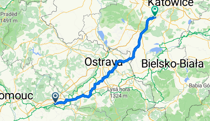
Hranice - Łaziska Górne
- -:--
- Duration
- 135.9 km
- Distance
- 658 m
- Ascent
- 608 m
- Descent
- ---
- Avg. speed
- ---
- Max. altitude

Route quality
Waytypes & surfaces along the route
Waytypes
Quiet road
59.8 km
(44 %)
Road
50.3 km
(37 %)
Surfaces
Paved
80.2 km
(59 %)
Unpaved
6.8 km
(5 %)
Asphalt
78.8 km
(58 %)
Gravel
2.7 km
(2 %)
Continue with Bikemap
Use, edit, or download this cycling route
You would like to ride 10 ETAP 5 czerwca niedziela or customize it for your own trip? Here is what you can do with this Bikemap route:
Free features
- Save this route as favorite or in collections
- Copy & plan your own version of this route
- Split it into stages to create a multi-day tour
- Sync your route with Garmin or Wahoo
Premium features
Free trial for 3 days, or one-time payment. More about Bikemap Premium.
- Navigate this route on iOS & Android
- Export a GPX / KML file of this route
- Create your custom printout (try it for free)
- Download this route for offline navigation
Discover more Premium features.
Get Bikemap PremiumFrom our community
Other popular routes starting in Hranice
 10 ETAP 5 czerwca niedziela
- Distance
- 135.9 km
- Ascent
- 658 m
- Descent
- 608 m
- Location
- Hranice, Olomoucký kraj, Czechia
 Do Týna na pivo přes Týn a Maleník
- Distance
- 28.3 km
- Ascent
- 437 m
- Descent
- 437 m
- Location
- Hranice, Olomoucký kraj, Czechia
 Hranice na Morave - Breclav
- Distance
- 170.9 km
- Ascent
- 385 m
- Descent
- 509 m
- Location
- Hranice, Olomoucký kraj, Czechia
 Hranice_na_Morave-Tesak-Mikulcin_Vrch-Kohutka-Kasarne-Makov-Bumbalka-Pustevny-Goleszów 4-5d - ??
- Distance
- 357.2 km
- Ascent
- 3,381 m
- Descent
- 3,324 m
- Location
- Hranice, Olomoucký kraj, Czechia
 Od Aše po Jablunkov, den 8.: Hranice - Frýdek-Místek
- Distance
- 61.6 km
- Ascent
- 598 m
- Descent
- 527 m
- Location
- Hranice, Olomoucký kraj, Czechia
 Hrabůvka_Potstat_Stritez_Hrabuvka_51_870
- Distance
- 50.5 km
- Ascent
- 837 m
- Descent
- 837 m
- Location
- Hranice, Olomoucký kraj, Czechia
 cyklostezka Rybáře - Osek n.B.
- Distance
- 12.3 km
- Ascent
- 41 m
- Descent
- 54 m
- Location
- Hranice, Olomoucký kraj, Czechia
 Cik-cak Valšovským polesím
- Distance
- 45.2 km
- Ascent
- 770 m
- Descent
- 770 m
- Location
- Hranice, Olomoucký kraj, Czechia
Open it in the app