

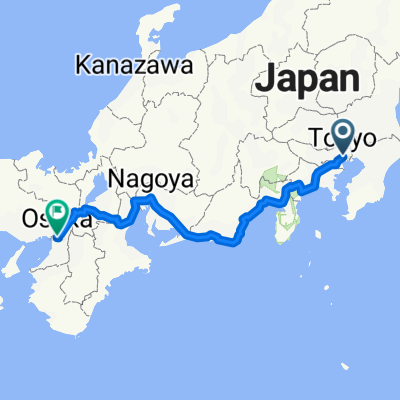
JT E1
A cycling route starting in Tokyo, Tokyo, Japan.
Overview
About this route
Etape 1 du Japan Tour
- -:--
- Duration
- 200 km
- Distance
- 2,569 m
- Ascent
- 268 m
- Descent
- ---
- Avg. speed
- ---
- Max. altitude
Continue with Bikemap
Use, edit, or download this cycling route
You would like to ride JT E1 or customize it for your own trip? Here is what you can do with this Bikemap route:
Free features
- Save this route as favorite or in collections
- Copy & plan your own version of this route
- Split it into stages to create a multi-day tour
- Sync your route with Garmin or Wahoo
Premium features
Free trial for 3 days, or one-time payment. More about Bikemap Premium.
- Navigate this route on iOS & Android
- Export a GPX / KML file of this route
- Create your custom printout (try it for free)
- Download this route for offline navigation
Discover more Premium features.
Get Bikemap PremiumFrom our community
Other popular routes starting in Tokyo
 Slow ride in Taito-Ku
- Distance
- 9.7 km
- Ascent
- 381 m
- Descent
- 375 m
- Location
- Tokyo, Tokyo, Japan
 20-12, Nakaochiai 4-Chōme, Shinjuku to Shinko 1-Chōme, Naka, Yokohama
- Distance
- 43.8 km
- Ascent
- 423 m
- Descent
- 455 m
- Location
- Tokyo, Tokyo, Japan
 160313_tour_de_tsukuruba#1
- Distance
- 134.9 km
- Ascent
- 177 m
- Descent
- 185 m
- Location
- Tokyo, Tokyo, Japan
 JUL-18-10-ARAKAWA
- Distance
- 90.1 km
- Ascent
- 148 m
- Descent
- 148 m
- Location
- Tokyo, Tokyo, Japan
 20200104_Shinozaki Park-Kasai Seaside Park
- Distance
- 38.8 km
- Ascent
- 672 m
- Descent
- 671 m
- Location
- Tokyo, Tokyo, Japan
 JR池袋駅 to JR有楽町駅(秋葉原経由)
- Distance
- 15.6 km
- Ascent
- 101 m
- Descent
- 134 m
- Location
- Tokyo, Tokyo, Japan
 Japedal Stage 1 - Tōkyō to Osaka (Tōkaidō)
- Distance
- 688.4 km
- Ascent
- 6,371 m
- Descent
- 6,372 m
- Location
- Tokyo, Tokyo, Japan
 Shioiri Park-Skytree-Taito-Ku
- Distance
- 16.6 km
- Ascent
- 820 m
- Descent
- 816 m
- Location
- Tokyo, Tokyo, Japan
Open it in the app