

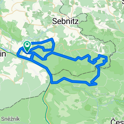
Häntzschelstiege - Wilde Hölle - Zwillingsstiege - Idagrotte
A cycling route starting in Bad Schandau, Saxony, Germany.
Overview
About this route
Der Beuthenfall ist nicht nur eine Haltestelle der historischen Kirnitzschtalbahn, sondern auch ein Wasserfall, der mit seinem Namen an die ehemalige Wildbienenzucht erinnert. Die Lichtenhainer Bauern hatten ihre Bienenstöcke, die so genannten Beuthen, dort aufgestellt. Schon um 1850 wurde eine Stauvorrichtung für den kleinen Wasserfall erreichtet, die heute noch in Betrieb ist.
- -:--
- Duration
- 9.7 km
- Distance
- 636 m
- Ascent
- 631 m
- Descent
- ---
- Avg. speed
- ---
- Max. altitude
Route highlights
Points of interest along the route
Point of interest after 1 km
leichter Klettersteig mit Schwierigkeit A/B - Anfänger- und Kindergeeignet (Sicherung mit Gurt und Klettersteig-Set) Sicherung mit Gurt und Klettersteig-Set empfohlen. fast durchgehende Drahtseilsicherung. nur im Aufstieg! gegliedert in zwei Teile - Zwischenausstieg nach dem unteren Teil möglich. Da
Point of interest after 1 km
Aussichtspunkt
Point of interest after 2.4 km
Der 458 m hohe Carolafels ist einer der schönsten Aussichtspunkte im Elbsandsteingebirge.
Point of interest after 3.1 km
Wildromantischer Pfad auf naturbelassenem Untergrund (felsig). verläuft vom Zugang "Carolafelsen" (oberer Einstieg) bis zum "Unteren Affensteinweg". verlangt Kondition (im Aufstieg) und ein wenig Trittsicherheit. Gerade im unteren Teil etwas kraxelig - Metallbügel als Tritt- und Greifhilfe vorhanden
Point of interest after 4.3 km
eher eine Stiege - kein richtiger Klettersteig. Schwierigkeit B. keine Drahtseilsicherung. Metallgriffe und Tritte. nur im Aufstieg! ausgesetzte Stellen. Sicherung mit Gurt und Klettersteig-Set zu empfehlen. Dauer etwa 10 bis 15 Minuten.
Point of interest after 7 km
Frienstein
Continue with Bikemap
Use, edit, or download this cycling route
You would like to ride Häntzschelstiege - Wilde Hölle - Zwillingsstiege - Idagrotte or customize it for your own trip? Here is what you can do with this Bikemap route:
Free features
- Save this route as favorite or in collections
- Copy & plan your own version of this route
- Sync your route with Garmin or Wahoo
Premium features
Free trial for 3 days, or one-time payment. More about Bikemap Premium.
- Navigate this route on iOS & Android
- Export a GPX / KML file of this route
- Create your custom printout (try it for free)
- Download this route for offline navigation
Discover more Premium features.
Get Bikemap PremiumFrom our community
Other popular routes starting in Bad Schandau
 Bad Schandau nach Dresden
- Distance
- 44.7 km
- Ascent
- 235 m
- Descent
- 337 m
- Location
- Bad Schandau, Saxony, Germany
 Elbsandsteintour
- Distance
- 68.3 km
- Ascent
- 828 m
- Descent
- 828 m
- Location
- Bad Schandau, Saxony, Germany
 Grosse Elbsandsteinrunde
- Distance
- 116.7 km
- Ascent
- 1,443 m
- Descent
- 1,397 m
- Location
- Bad Schandau, Saxony, Germany
 Elbet
Elbet- Distance
- 60.2 km
- Ascent
- 923 m
- Descent
- 932 m
- Location
- Bad Schandau, Saxony, Germany
 Bad Schandau, Bad Schandau to Friedrichstadt, Dresden
- Distance
- 48.2 km
- Ascent
- 389 m
- Descent
- 394 m
- Location
- Bad Schandau, Saxony, Germany
 2005 - Elberadweg Bad Schandau - Decin (CZ) - Leipzig
- Distance
- 304 km
- Ascent
- 797 m
- Descent
- 853 m
- Location
- Bad Schandau, Saxony, Germany
 Bad Schandau - Johnsdorf
- Distance
- 52.6 km
- Ascent
- 945 m
- Descent
- 657 m
- Location
- Bad Schandau, Saxony, Germany
 unlöschbare MTB-Tour
- Distance
- 68.2 km
- Ascent
- 1,428 m
- Descent
- 1,420 m
- Location
- Bad Schandau, Saxony, Germany
Open it in the app