

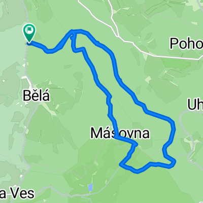
Cetviny - Sandl - Nebelstein
A cycling route starting in Malonty, Jihočeský kraj, Czechia.
Overview
About this route
Cetviny-Mairspindt-Unterwald-Hacklbrunn-Sandl-pramen Malše-Kohlstatt-trojmezí-Stadlberg-pramen Lužnice-Pohoří na Šumavě-Kapelníkův r.-Myslivna-býv. Terčí Huť-býv. Skleněné Hutě-býv. Stříbrné Hutě-Joachimstal-Angelbach-Harmanschlag-Nebelstein-Schwarzau-prales Žofín-Žofín-Huťský r.-Uhlíšťský r.-Leopoldov-Horní Příbrání-Dolní Příbrání-Cetviny
- -:--
- Duration
- 80.5 km
- Distance
- 1,163 m
- Ascent
- 1,163 m
- Descent
- ---
- Avg. speed
- ---
- Max. altitude

Route quality
Waytypes & surfaces along the route
Waytypes
Track
39.5 km
(49 %)
Road
19.3 km
(24 %)
Surfaces
Paved
31.4 km
(39 %)
Unpaved
26.6 km
(33 %)
Asphalt
28.2 km
(35 %)
Gravel
15.3 km
(19 %)
Continue with Bikemap
Use, edit, or download this cycling route
You would like to ride Cetviny - Sandl - Nebelstein or customize it for your own trip? Here is what you can do with this Bikemap route:
Free features
- Save this route as favorite or in collections
- Copy & plan your own version of this route
- Split it into stages to create a multi-day tour
- Sync your route with Garmin or Wahoo
Premium features
Free trial for 3 days, or one-time payment. More about Bikemap Premium.
- Navigate this route on iOS & Android
- Export a GPX / KML file of this route
- Create your custom printout (try it for free)
- Download this route for offline navigation
Discover more Premium features.
Get Bikemap PremiumFrom our community
Other popular routes starting in Malonty
 Myslivna
- Distance
- 17.6 km
- Ascent
- 432 m
- Descent
- 433 m
- Location
- Malonty, Jihočeský kraj, Czechia
 Baronův Most-Hojná Voda- Harbach rašelinové lázně
- Distance
- 30.6 km
- Ascent
- 530 m
- Descent
- 708 m
- Location
- Malonty, Jihočeský kraj, Czechia
 Okruh-Pohorská Ves, Pohoří na Šumavě a zpět
- Distance
- 34.1 km
- Ascent
- 797 m
- Descent
- 789 m
- Location
- Malonty, Jihočeský kraj, Czechia
 Cetviny - Sandl - Nebelstein
- Distance
- 80.5 km
- Ascent
- 1,163 m
- Descent
- 1,163 m
- Location
- Malonty, Jihočeský kraj, Czechia
 Cetviny
- Distance
- 13.5 km
- Ascent
- 259 m
- Descent
- 258 m
- Location
- Malonty, Jihočeský kraj, Czechia
 Huťský rybník, Vyhlídka
- Distance
- 14.8 km
- Ascent
- 409 m
- Descent
- 412 m
- Location
- Malonty, Jihočeský kraj, Czechia
 Pomalá jízda
- Distance
- 24.1 km
- Ascent
- 583 m
- Descent
- 615 m
- Location
- Malonty, Jihočeský kraj, Czechia
 Doppler
- Distance
- 14.5 km
- Ascent
- 395 m
- Descent
- 391 m
- Location
- Malonty, Jihočeský kraj, Czechia
Open it in the app