

Single-Trail-Runde im Pfälzerwald
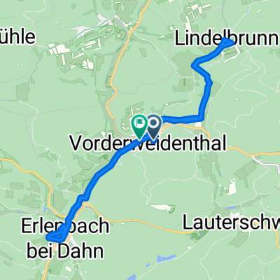
A cycling route starting in Vorderweidenthal, Rhineland-Palatinate, Germany.
Overview
About this route
Eine wahnsinnig schöne MTB-Tour, die viele, viele Kilometer Singletrail enthält.
Start und Ziel ist ein Wanderparkplatz nahe der Kreuzung zwischen Erlenbach und Vorderweidenthal. Es beginnt recht heftig mit einem Trail, um später über Waldwege und wieder Trails hinunter nach Hauenstein zu gehen. Von dort aus geht es fast ausschließlich auf Trails bis nach Dahn, ein Hochgenuss. Lediglich ein kleines Stück zum Römerfelsen hinauf muss man schieben, aber das lohnt sich für den fantastischen Ausblick. Von Dahn aus am Fluss entlang und danach ein Stück Straße bis hinter Schindhard. Danach gehts wieder in den Wald und letztlich einen steilen Anstieg hoch, nach dem man wieder auf die vorher gefahrene Route trifft. Hier bekommt man als Belohnung für den heftigen Beginn einen fantastischen Downhill zurück zum Parkplatz.- -:--
- Duration
- 37.1 km
- Distance
- 748 m
- Ascent
- 749 m
- Descent
- ---
- Avg. speed
- ---
- Max. altitude

Continue with Bikemap
Use, edit, or download this cycling route
You would like to ride Single-Trail-Runde im Pfälzerwald or customize it for your own trip? Here is what you can do with this Bikemap route:
Free features
- Save this route as favorite or in collections
- Copy & plan your own version of this route
- Sync your route with Garmin or Wahoo
Premium features
Free trial for 3 days, or one-time payment. More about Bikemap Premium.
- Navigate this route on iOS & Android
- Export a GPX / KML file of this route
- Create your custom printout (try it for free)
- Download this route for offline navigation
Discover more Premium features.
Get Bikemap PremiumFrom our community
Other popular routes starting in Vorderweidenthal
 Single-Trail-Runde im Pfälzerwald
- Distance
- 37.1 km
- Ascent
- 748 m
- Descent
- 749 m
- Location
- Vorderweidenthal, Rhineland-Palatinate, Germany
 Brühlstraße 10, Vorderweidenthal nach Im Entenbruch 5, Vorderweidenthal
- Distance
- 9.2 km
- Ascent
- 443 m
- Descent
- 447 m
- Location
- Vorderweidenthal, Rhineland-Palatinate, Germany
 kleine Tür 03.08.25
- Distance
- 12 km
- Ascent
- 278 m
- Descent
- 342 m
- Location
- Vorderweidenthal, Rhineland-Palatinate, Germany
 Tour 14+15 Dahn
- Distance
- 64.1 km
- Ascent
- 1,241 m
- Descent
- 1,239 m
- Location
- Vorderweidenthal, Rhineland-Palatinate, Germany
 Erlenbach Rundweg
- Distance
- 43.3 km
- Ascent
- 697 m
- Descent
- 697 m
- Location
- Vorderweidenthal, Rhineland-Palatinate, Germany
 9 Seehof - Mettlach
- Distance
- 139.3 km
- Ascent
- 1,943 m
- Descent
- 2,005 m
- Location
- Vorderweidenthal, Rhineland-Palatinate, Germany
 Bethof 24, Vorderweidenthal nach Eybergstraße, Dahn
- Distance
- 20.8 km
- Ascent
- 467 m
- Descent
- 505 m
- Location
- Vorderweidenthal, Rhineland-Palatinate, Germany
 Tour 9+10 Bad Bergzabern
- Distance
- 68.1 km
- Ascent
- 1,391 m
- Descent
- 1,391 m
- Location
- Vorderweidenthal, Rhineland-Palatinate, Germany
Open it in the app