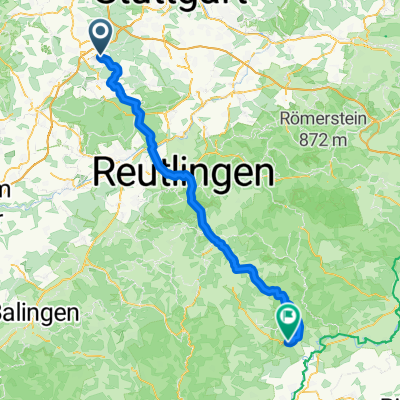
böblingen schönbuchtour
A cycling route starting in Böblingen, Baden-Wurttemberg, Germany.
Overview
About this route
from the murkenbachweg parking route through the schönbuch
- -:--
- Duration
- 43.5 km
- Distance
- 399 m
- Ascent
- 378 m
- Descent
- ---
- Avg. speed
- 561 m
- Max. altitude
Route quality
Waytypes & surfaces along the route
Waytypes
Track
32.6 km
(75 %)
Path
3.9 km
(9 %)
Surfaces
Paved
18.3 km
(42 %)
Unpaved
24.8 km
(57 %)
Asphalt
18.3 km
(42 %)
Gravel
17.8 km
(41 %)
Continue with Bikemap
Use, edit, or download this cycling route
You would like to ride böblingen schönbuchtour or customize it for your own trip? Here is what you can do with this Bikemap route:
Free features
- Save this route as favorite or in collections
- Copy & plan your own version of this route
- Sync your route with Garmin or Wahoo
Premium features
Free trial for 3 days, or one-time payment. More about Bikemap Premium.
- Navigate this route on iOS & Android
- Export a GPX / KML file of this route
- Create your custom printout (try it for free)
- Download this route for offline navigation
Discover more Premium features.
Get Bikemap PremiumFrom our community
Other popular routes starting in Böblingen
Brunnenstraße, Böblingen nach Hauptstraße, Zwiefalten- Distance
- 79 km
- Ascent
- 1,199 m
- Descent
- 1,090 m
- Location
- Böblingen, Baden-Wurttemberg, Germany
schönbuch grilltag- Distance
- 34.4 km
- Ascent
- 402 m
- Descent
- 427 m
- Location
- Böblingen, Baden-Wurttemberg, Germany
Rund um Böblingen - alles mit drin- Distance
- 40.3 km
- Ascent
- 297 m
- Descent
- 297 m
- Location
- Böblingen, Baden-Wurttemberg, Germany
Testroute- Distance
- 16.7 km
- Ascent
- 88 m
- Descent
- 99 m
- Location
- Böblingen, Baden-Wurttemberg, Germany
Böblingen-Siebenmühlental-Böblingen- Distance
- 36.7 km
- Ascent
- 431 m
- Descent
- 388 m
- Location
- Böblingen, Baden-Wurttemberg, Germany
Böblingen - Meistern, Gültigen Heuweg- Distance
- 52.8 km
- Ascent
- 1,036 m
- Descent
- 785 m
- Location
- Böblingen, Baden-Wurttemberg, Germany
Panzer 10k Loop- Distance
- 9.8 km
- Ascent
- 248 m
- Descent
- 248 m
- Location
- Böblingen, Baden-Wurttemberg, Germany
Böblingen - Besigheim- Distance
- 46.9 km
- Ascent
- 346 m
- Descent
- 527 m
- Location
- Böblingen, Baden-Wurttemberg, Germany
Open it in the app

