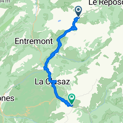
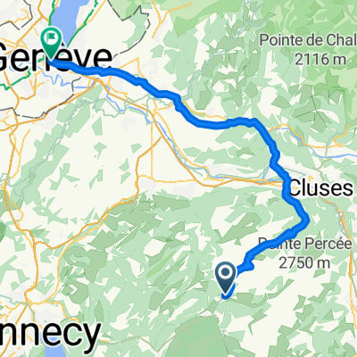
20221005 Grand-Bornand Tour du Lachat
- 27.8 km
- 2,210 m
- 2,204 m
- Le Grand-Bornand, Auvergne-Rhône-Alpes, France
A cycling route starting in Le Grand-Bornand, Auvergne-Rhône-Alpes, France.
Overview
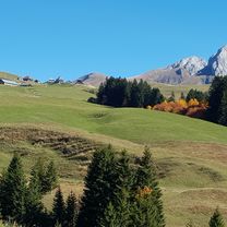
The first short stretch to St.Jean-de-Sixt should be completed the night before, as the more attractive campsite is located here. A gentle climb follows, which becomes increasingly beautiful along the way to the Col des Aravis. A little away from the bustle that reigns there, it is worth taking an extended break to absorb the splendid surroundings. Descending past a few settlements, the road continues above a narrow gorge and one arrives at the church of Flumet. By going around it to the right, one can avoid the one-way street and then cross the deep valley incision on the bridge behind it. Here begins the also quite easy, but long climb through charming scenery to the ski resort of les Saisies at the pass summit. Once this is passed, it descends to a fork, where a counter ascent can be seen straight ahead. Instead of reaching the stage destination via this route, one sharply turns left and goes through the lovely little village of Hauteluce, at the end of which a sign points us toward the steadily declining road to Beaufort, where the camping site located a bit outside offers a convenient and quiet overnight option.
Seventh of twenty stages of a cycling tour around Switzerland. After this short stage over two moderately strenuous passes through areas strongly influenced by winter sports, but otherwise charming and scenic, one can relax in the lovely destination and gather strength for the upcoming pass crossings.
created this 10 years ago
Route quality
Road
8.6 km
(15 %)
Quiet road
1.7 km
(3 %)
Paved
53.5 km
(93 %)
Asphalt
53.5 km
(93 %)
Undefined
4 km
(7 %)
Continue with Bikemap
You would like to ride (07) Le Grand Bornand - Beaufort or customize it for your own trip? Here is what you can do with this Bikemap route:
Free trial for 3 days, or one-time payment. More about Bikemap Premium.
Discover more Premium features.
Get Bikemap PremiumFrom our community
Open it in the app