

Recording from 27 September 3:57 PM
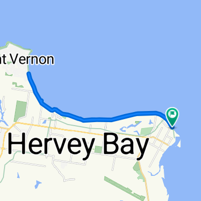
A cycling route starting in Urangan, Queensland, Australia.
Overview
About this route
Half of The Link with a loop around Pt Vernon.
- 1 h 26 min
- Duration
- 29.4 km
- Distance
- 82 m
- Ascent
- 83 m
- Descent
- 20.4 km/h
- Avg. speed
- ---
- Max. altitude

Route quality
Waytypes & surfaces along the route
Waytypes
Cycleway
15.3 km
(52 %)
Quiet road
6.8 km
(23 %)
Surfaces
Paved
22.9 km
(78 %)
Asphalt
12 km
(41 %)
Paved (undefined)
10 km
(34 %)
Continue with Bikemap
Use, edit, or download this cycling route
You would like to ride Recording from 27 September 3:57 PM or customize it for your own trip? Here is what you can do with this Bikemap route:
Free features
- Save this route as favorite or in collections
- Copy & plan your own version of this route
- Sync your route with Garmin or Wahoo
Premium features
Free trial for 3 days, or one-time payment. More about Bikemap Premium.
- Navigate this route on iOS & Android
- Export a GPX / KML file of this route
- Create your custom printout (try it for free)
- Download this route for offline navigation
Discover more Premium features.
Get Bikemap PremiumFrom our community
Other popular routes starting in Urangan
 Esplanade 606, Urangan to Esplanade 606, Urangan
- Distance
- 20.8 km
- Ascent
- 89 m
- Descent
- 103 m
- Location
- Urangan, Queensland, Australia
 730 Boat Harbour Dr, Urangan to 11 Harrison Cct, Urangan
- Distance
- 6.8 km
- Ascent
- 13 m
- Descent
- 16 m
- Location
- Urangan, Queensland, Australia
 1–5 Pier St, Urangan to 11 Pier St, Urangan
- Distance
- 25.6 km
- Ascent
- 599 m
- Descent
- 596 m
- Location
- Urangan, Queensland, Australia
 Esplanade 606, Urangan to Esplanade 606, Urangan
- Distance
- 29 km
- Ascent
- 146 m
- Descent
- 157 m
- Location
- Urangan, Queensland, Australia
 Recording from 22 September 3:06 PM
- Distance
- 29 km
- Ascent
- 57 m
- Descent
- 56 m
- Location
- Urangan, Queensland, Australia
 Recovered Route
- Distance
- 9 km
- Ascent
- 27 m
- Descent
- 36 m
- Location
- Urangan, Queensland, Australia
 Ellengowan Street 9-15, Urangan to Hibiscus Street 76, Urangan
- Distance
- 5.7 km
- Ascent
- 7 m
- Descent
- 19 m
- Location
- Urangan, Queensland, Australia
 Circuit of Hervey Bay
- Distance
- 29.9 km
- Ascent
- 132 m
- Descent
- 129 m
- Location
- Urangan, Queensland, Australia
Open it in the app