
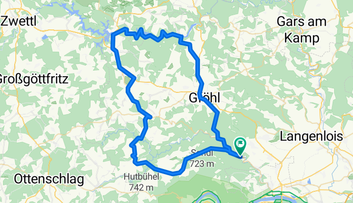
Senftenberg - Gföhl - Dobra-Stausee - Albrechtsberg
A cycling route starting in Senftenberg, Lower Austria, Austria.
Overview
About this route
Senftenberg - Gföhl - Dobra-Stausee - Albrechtsberg
- -:--
- Duration
- 75.8 km
- Distance
- 1,086 m
- Ascent
- 1,086 m
- Descent
- ---
- Avg. speed
- ---
- Max. altitude
Continue with Bikemap
Use, edit, or download this cycling route
You would like to ride Senftenberg - Gföhl - Dobra-Stausee - Albrechtsberg or customize it for your own trip? Here is what you can do with this Bikemap route:
Free features
- Save this route as favorite or in collections
- Copy & plan your own version of this route
- Sync your route with Garmin or Wahoo
Premium features
Free trial for 3 days, or one-time payment. More about Bikemap Premium.
- Navigate this route on iOS & Android
- Export a GPX / KML file of this route
- Create your custom printout (try it for free)
- Download this route for offline navigation
Discover more Premium features.
Get Bikemap PremiumFrom our community
Other popular routes starting in Senftenberg
 Ostertour?
- Distance
- 271.5 km
- Ascent
- 4,334 m
- Descent
- 4,334 m
- Location
- Senftenberg, Lower Austria, Austria
 L73 67 nach L73 67
- Distance
- 70.3 km
- Ascent
- 1,171 m
- Descent
- 1,171 m
- Location
- Senftenberg, Lower Austria, Austria
 Senftenberg - Gföhl - Dobra-Stausee - Albrechtsberg
- Distance
- 75.8 km
- Ascent
- 1,086 m
- Descent
- 1,086 m
- Location
- Senftenberg, Lower Austria, Austria
 Tag 3 nach Zwentendorf
- Distance
- 36.1 km
- Ascent
- 173 m
- Descent
- 245 m
- Location
- Senftenberg, Lower Austria, Austria
 Route nach Reiten
- Distance
- 59.2 km
- Ascent
- 804 m
- Descent
- 339 m
- Location
- Senftenberg, Lower Austria, Austria
 Senftenberg-Drosendorf alternativ
- Distance
- 72.8 km
- Ascent
- 1,240 m
- Descent
- 1,072 m
- Location
- Senftenberg, Lower Austria, Austria
 Kirchenberg 1, Senftenberg nach Dürnstein 82
- Distance
- 10.3 km
- Ascent
- 375 m
- Descent
- 396 m
- Location
- Senftenberg, Lower Austria, Austria
 BZAI D4 Long opt.
- Distance
- 22.4 km
- Ascent
- 423 m
- Descent
- 495 m
- Location
- Senftenberg, Lower Austria, Austria
Open it in the app