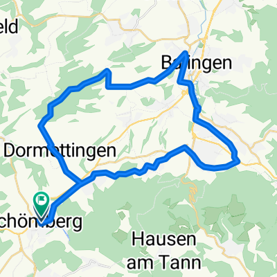
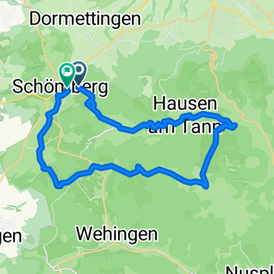
Lochen-Plettenberg-Tour
A cycling route starting in Schömberg, Baden-Wurttemberg, Germany.
Overview
About this route
From Schömberg on the old Deilinger road over Heidenhof to Tieringen. Up the Lochen to Plettenberg and back to Schömberg. Everything included from asphalt road, gravel path, single trail, pushing sections, carrying section.
- -:--
- Duration
- 30 km
- Distance
- 713 m
- Ascent
- 713 m
- Descent
- ---
- Avg. speed
- ---
- Max. altitude
Continue with Bikemap
Use, edit, or download this cycling route
You would like to ride Lochen-Plettenberg-Tour or customize it for your own trip? Here is what you can do with this Bikemap route:
Free features
- Save this route as favorite or in collections
- Copy & plan your own version of this route
- Sync your route with Garmin or Wahoo
Premium features
Free trial for 3 days, or one-time payment. More about Bikemap Premium.
- Navigate this route on iOS & Android
- Export a GPX / KML file of this route
- Create your custom printout (try it for free)
- Download this route for offline navigation
Discover more Premium features.
Get Bikemap PremiumFrom our community
Other popular routes starting in Schömberg
- Schömberg-Villingen Furtwangen- Simonswald- Waldkirch-Kandel- Thurner-Joostal-Neustadt-Bräunlingen-Donaueschingen-Trossingen-Frittlingen-Schömberg
- Distance
- 205.1 km
- Ascent
- 2,175 m
- Descent
- 2,173 m
- Location
- Schömberg, Baden-Wurttemberg, Germany
- Trainingsrunde Groß
- Distance
- 24 km
- Ascent
- 175 m
- Descent
- 174 m
- Location
- Schömberg, Baden-Wurttemberg, Germany
- Schömberg-Villingen Furtwangen-B500[- Simonswald- Waldkirch-Kandel- auslassen]Thurner-Joostal-Neustadt-Bräunlingen-Donaueschingen-Trossingen-Frittlingen-Schömbe
- Distance
- 157.9 km
- Ascent
- 1,197 m
- Descent
- 1,195 m
- Location
- Schömberg, Baden-Wurttemberg, Germany
- Lochen-Plettenberg-Tour
- Distance
- 30 km
- Ascent
- 713 m
- Descent
- 713 m
- Location
- Schömberg, Baden-Wurttemberg, Germany
- Schömberg Laufrunde
- Distance
- 4.9 km
- Ascent
- 105 m
- Descent
- 105 m
- Location
- Schömberg, Baden-Wurttemberg, Germany
- Tappa 4 : Schomberg - Freudenstadt
- Distance
- 81.4 km
- Ascent
- 803 m
- Descent
- 753 m
- Location
- Schömberg, Baden-Wurttemberg, Germany
- Schömberg; Lochen ; Harras; Schörzingen; Schömberg
- Distance
- 42.9 km
- Ascent
- 578 m
- Descent
- 578 m
- Location
- Schömberg, Baden-Wurttemberg, Germany
- Lochen Obernheim
- Distance
- 35.9 km
- Ascent
- 566 m
- Descent
- 567 m
- Location
- Schömberg, Baden-Wurttemberg, Germany
Open it in the app