

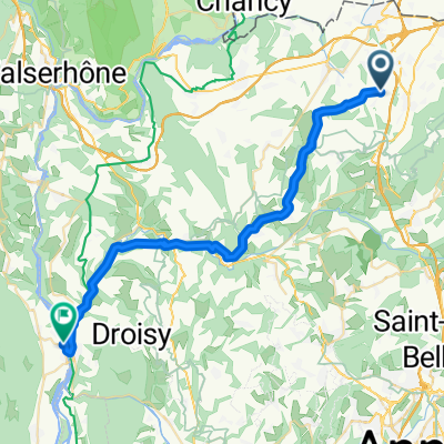
Montailloux VTT Salève 2015 (42 km)
A cycling route starting in Feigères, Auvergne-Rhône-Alpes, France.
Overview
About this route
The route of the Rando VTT 2015 organized by the Montailloux VTT Club. Start in Présilly, destination the Salève. Loop of 42 km; routes of 18, 30, 37, and 50 km were also offered.Distance: 42 km Positive elevation: 1300 m Maximum altitude: 1330 m (Col des Pitons) More information at www.montailloux.fr and www.europebybike.info
- -:--
- Duration
- 42.1 km
- Distance
- 1,142 m
- Ascent
- 1,131 m
- Descent
- ---
- Avg. speed
- ---
- Max. altitude

Route quality
Waytypes & surfaces along the route
Waytypes
Track
19.8 km
(47 %)
Path
13 km
(31 %)
Surfaces
Paved
2.9 km
(7 %)
Unpaved
22.7 km
(54 %)
Gravel
10.9 km
(26 %)
Unpaved (undefined)
6.7 km
(16 %)
Continue with Bikemap
Use, edit, or download this cycling route
You would like to ride Montailloux VTT Salève 2015 (42 km) or customize it for your own trip? Here is what you can do with this Bikemap route:
Free features
- Save this route as favorite or in collections
- Copy & plan your own version of this route
- Sync your route with Garmin or Wahoo
Premium features
Free trial for 3 days, or one-time payment. More about Bikemap Premium.
- Navigate this route on iOS & Android
- Export a GPX / KML file of this route
- Create your custom printout (try it for free)
- Download this route for offline navigation
Discover more Premium features.
Get Bikemap PremiumFrom our community
Other popular routes starting in Feigères
 22-02
22-02- Distance
- 68.9 km
- Ascent
- 1,333 m
- Descent
- 1,246 m
- Location
- Feigères, Auvergne-Rhône-Alpes, France
 De 113 Route de Pré Vally, Feigères à Route de Pré Vally, Feigères
- Distance
- 40.1 km
- Ascent
- 1,043 m
- Descent
- 1,045 m
- Location
- Feigères, Auvergne-Rhône-Alpes, France
 Itinéraire modéré en Feigères
- Distance
- 19.4 km
- Ascent
- 2,006 m
- Descent
- 1,991 m
- Location
- Feigères, Auvergne-Rhône-Alpes, France
 annecy
- Distance
- 27.5 km
- Ascent
- 428 m
- Descent
- 625 m
- Location
- Feigères, Auvergne-Rhône-Alpes, France
 Francia Alpok vége
- Distance
- 18 km
- Ascent
- 77 m
- Descent
- 334 m
- Location
- Feigères, Auvergne-Rhône-Alpes, France
 cernex tournelles
- Distance
- 25.1 km
- Ascent
- 167 m
- Descent
- 415 m
- Location
- Feigères, Auvergne-Rhône-Alpes, France
 De 20 Chemin de Clairjoie, Présilly à 40 Chemin de la Cure, Présilly
- Distance
- 218.9 km
- Ascent
- 2,041 m
- Descent
- 1,995 m
- Location
- Feigères, Auvergne-Rhône-Alpes, France
 camp le terroir - camp le nant mantraz tandem 2017
- Distance
- 33.4 km
- Ascent
- 289 m
- Descent
- 634 m
- Location
- Feigères, Auvergne-Rhône-Alpes, France
Open it in the app