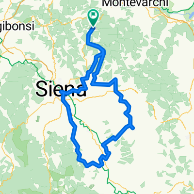
Eroica_78km official (2014)
A cycling route starting in Gaiole in Chianti, Tuscany, Italy.
Overview
About this route
Eroica_78km official
(cloned from route 3289542)
- -:--
- Duration
- 77.9 km
- Distance
- 1,363 m
- Ascent
- 1,363 m
- Descent
- ---
- Avg. speed
- ---
- Max. altitude
Route quality
Waytypes & surfaces along the route
Waytypes
Road
25.7 km
(33 %)
Quiet road
17.9 km
(23 %)
Surfaces
Paved
34.3 km
(44 %)
Unpaved
27.2 km
(35 %)
Asphalt
34.3 km
(44 %)
Gravel
20.2 km
(26 %)
Continue with Bikemap
Use, edit, or download this cycling route
You would like to ride Eroica_78km official (2014) or customize it for your own trip? Here is what you can do with this Bikemap route:
Free features
- Save this route as favorite or in collections
- Copy & plan your own version of this route
- Sync your route with Garmin or Wahoo
Premium features
Free trial for 3 days, or one-time payment. More about Bikemap Premium.
- Navigate this route on iOS & Android
- Export a GPX / KML file of this route
- Create your custom printout (try it for free)
- Download this route for offline navigation
Discover more Premium features.
Get Bikemap PremiumFrom our community
Other popular routes starting in Gaiole in Chianti
L'Eroica Leisure Route 32km- Distance
- 32.1 km
- Ascent
- 359 m
- Descent
- 356 m
- Location
- Gaiole in Chianti, Tuscany, Italy
Gaiole dream 1- Distance
- 62.7 km
- Ascent
- 1,121 m
- Descent
- 1,121 m
- Location
- Gaiole in Chianti, Tuscany, Italy
Route nach Badia Coltibuono -Castello di Brolo- Distance
- 36.9 km
- Ascent
- 754 m
- Descent
- 806 m
- Location
- Gaiole in Chianti, Tuscany, Italy
Località Badia a Coltibuono nach Badia Coltibuono- Distance
- 17.4 km
- Ascent
- 394 m
- Descent
- 455 m
- Location
- Gaiole in Chianti, Tuscany, Italy
Eroica- Distance
- 206.7 km
- Ascent
- 1,861 m
- Descent
- 1,864 m
- Location
- Gaiole in Chianti, Tuscany, Italy
Brolio Castle to Siena- Distance
- 22.5 km
- Ascent
- 0 m
- Descent
- 0 m
- Location
- Gaiole in Chianti, Tuscany, Italy
TERRA EROICA - L'Eroica (percorso completo/permanent route)- Distance
- 207.1 km
- Ascent
- 2,997 m
- Descent
- 2,986 m
- Location
- Gaiole in Chianti, Tuscany, Italy
Toskana_1- Distance
- 74.8 km
- Ascent
- 1,098 m
- Descent
- 1,098 m
- Location
- Gaiole in Chianti, Tuscany, Italy
Open it in the app


