
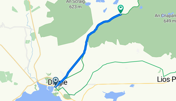
CONNOR PASS, por Dingle
A cycling route starting in Dingle, Munster, Ireland.
Overview
About this route
Subida.
- -:--
- Duration
- 6.8 km
- Distance
- 452 m
- Ascent
- 45 m
- Descent
- ---
- Avg. speed
- ---
- Avg. speed
Route quality
Waytypes & surfaces along the route
Waytypes
Busy road
3.8 km
(57 %)
Quiet road
3 km
(43 %)
Undefined
0 km
(<1 %)
Surfaces
Paved
5.3 km
(78 %)
Asphalt
5.3 km
(78 %)
Undefined
1.5 km
(22 %)
Continue with Bikemap
Use, edit, or download this cycling route
You would like to ride CONNOR PASS, por Dingle or customize it for your own trip? Here is what you can do with this Bikemap route:
Free features
- Save this route as favorite or in collections
- Copy & plan your own version of this route
- Sync your route with Garmin or Wahoo
Premium features
Free trial for 3 days, or one-time payment. More about Bikemap Premium.
- Navigate this route on iOS & Android
- Export a GPX / KML file of this route
- Create your custom printout (try it for free)
- Download this route for offline navigation
Discover more Premium features.
Get Bikemap PremiumFrom our community
Other popular routes starting in Dingle
 Dingle a Killarney
- Distance
- 66.3 km
- Ascent
- 417 m
- Descent
- 388 m
- Location
- Dingle, Munster, Ireland
 Slea Head
- Distance
- 39.3 km
- Ascent
- 286 m
- Descent
- 286 m
- Location
- Dingle, Munster, Ireland
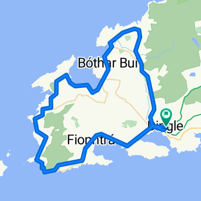
 Slea Head Loop
- Distance
- 50.3 km
- Ascent
- 2,893 m
- Descent
- 2,885 m
- Location
- Dingle, Munster, Ireland
 Dingle - Dingle
- Distance
- 40.1 km
- Ascent
- 423 m
- Descent
- 423 m
- Location
- Dingle, Munster, Ireland
 Ring of Dingle
- Distance
- 78.2 km
- Ascent
- 456 m
- Descent
- 456 m
- Location
- Dingle, Munster, Ireland
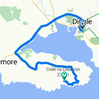 Dingle peninsula
- Distance
- 9.8 km
- Ascent
- 302 m
- Descent
- 149 m
- Location
- Dingle, Munster, Ireland
 Dingle
- Distance
- 56.1 km
- Ascent
- 540 m
- Descent
- 540 m
- Location
- Dingle, Munster, Ireland
 R559, Ballydavid à Cosán na Naomh, Ballydavid
- Distance
- 48.1 km
- Ascent
- 867 m
- Descent
- 797 m
- Location
- Dingle, Munster, Ireland
Open it in the app