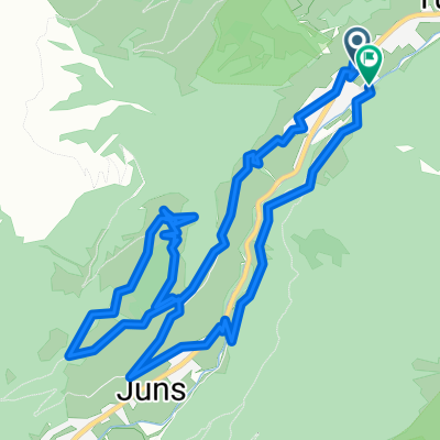


Mayrhofen - Hintertux - Mayrhofen
- 59.4 km
- 1,901 m
- 1,901 m
- Mayrhofen, Tyrol, Austria
A cycling route starting in Mayrhofen, Tyrol, Austria.
Overview
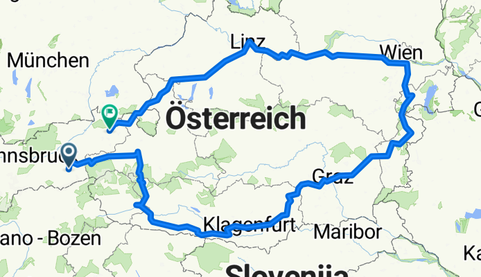
1.TAG:<br />On Friday, 03.07.2009 I started in Mayrhofen around 13:30; light rain; over the Gerlos Pass to Zell am See; <br />1. Overnight stay at hotel/pension 'Latini' single room with breakfast EUR 25.00 - recommended.<br />2.TAG:<br />After a hearty and generous breakfast at 'Latini', I set off in fog and light rain towards Grossglockner. Upon arriving at Glockner, I had to put on rain pants and rain jacket, otherwise I would probably have frozen. After about 2km descent to the eastern Tyrolean side - wonderful sunshine and an estimated 25°C warmer. Further over Iselsberg to the first capital LIENZ. Then over the Geilbergpass to St. Daniel. <br />2. Overnight stay at the guesthouse 'Grünwald' with breakfast EUR 29.00. Even at dinner, many 'restaurants' could learn a thing or two from this 'tavern'; highly recommended!!<br />3.TAG:<br />Strengthened by the breakfast, I continued towards Wörthersee; there was the annual Iron-Man event in full swing. Further on to Klagenfurt, Völkermarkt to Griffen. Immediately found a nice guesthouse (unfortunately forgot the name), plenty and good dinner, room ok, affordable price.<br />4.TAG:<br />After a hearty breakfast, I started towards Styria. Griffen, Wolfsberg, Preitenegg, Pack, Edelschrott, Hitzendorf, Graz, Gleisdorf. It poured all day; that day I saw about 1000 fire trucks that had to pump out flooded basements everywhere. But luckily it was not cold, so the dampness was not too bothersome ;-)<br />Spent the 4th night at the hotel 'Brauner Hirsch' for EUR 48.00 with buffet breakfast. Dinner at the same place was also acceptable.<br />5.TAG:<br />Gleisdorf, Hartberg, Oberpullendorf, Eisenstadt, Hornstein. The weather had a bit of everything; heat - rain - sun.<br />At the first 'vacancy' sign I immediately found a place. Breakfast guesthouse 'Schober' with bed and breakfast EUR 49.00. Beautiful courtyard, rooms and sanitary facilities up to date. Right across the street I recharged my batteries in a wine tavern with traditional food.<br />6.TAG:<br />Strengthened by the generous breakfast buffet, I continued: Hornstein, Vienna, Pressbaum, St.Pölten, Melk, Klein Pöchlarn. In Vienna, I got lost about 20 times; a cold north-west wind blew against me all day, which left me feeling physically and mentally worn out so I took the first 'drop-in' for the night. Mistake! Guesthouse 'Paradiso' with bed and breakfast EUR 28.00 I CANNOT recommend! (you learn from mistakes)<br />7.TAG:<br />After refusing the 'breakfast' at the guesthouse, I strengthened myself with a carbohydrate bar, bread roll with meat, and cola before I faced the lively north-west wind (according to the radio). On the flat Danube cycle path, I pedaled at 20 km/h and felt like I was pushing 200W. The retirees coming towards me at about 40 km/h, with shopping baskets on their handlebars, socks and sandals on their feet motivated me even more. The route took me from Klein-Pöchlarn along the Danube to Linz; then over to Wels to Vöcklermarkt, where I finally found a proper countryside guesthouse after about an hour of searching and a few detours. Guesthouse 'Riedl' with bed and breakfast EUR 31.00, dinner was sensational and the rooms were brand new.<br />8.TAG:<br />After a perfect breakfast, I set off: Vöcklermarkt, Salzburg, Lofer, St. Johann i. Tirol. On this last day, it started to rain right after the start. The temperature also dropped significantly so that despite the rain clothes, I felt cold. Just before Lofer, I made the difficult decision to abandon my tour in St. Johann i. Tirol and asked my girlfriend to pick me up. When I rolled down from the Strub Pass, the weather turned nice and warm. Nevertheless, I was glad to switch into dry clothes in St. Johann and take a seat in a soft car seat.Since I did not complete the circuit, I will likely have to ride it again ;-)
created this 16 years ago
Route quality
Quiet road
111.5 km
(10 %)
Road
89.2 km
(8 %)
Paved
791.7 km
(71 %)
Unpaved
55.8 km
(5 %)
Asphalt
780.5 km
(70 %)
Gravel
22.3 km
(2 %)
Route highlights
1. Übernachtung, Zell am See
2. Übernachtung Gasthof Grünwald
3. Übernachtung, Griffen
4. Übernachtung, Gleisdorf
5. Übernachtung, Hornstein
6. Übernachtung, Klein Pöchlarn
7. Übernachtung, Vöcklermarkt
Continue with Bikemap
You would like to ride 7 Hauptstädte Österreichs or customize it for your own trip? Here is what you can do with this Bikemap route:
Free trial for 3 days, or one-time payment. More about Bikemap Premium.
Discover more Premium features.
Get Bikemap PremiumFrom our community
Open it in the app