

Grenoble - Alp d´Huez - Grenoble
A cycling route starting in Grenoble, Auvergne-Rhône-Alpes, France.
Overview
About this route
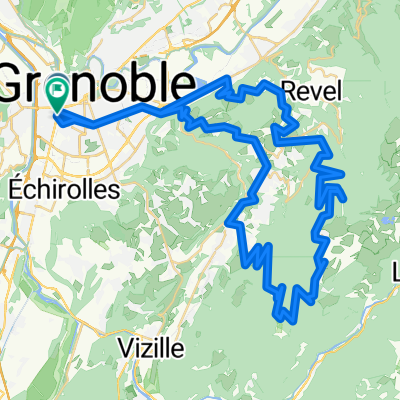
Rundkurs von Grenoble nach Alp d´Huez. Vom Zentrum auf der Avenue Jean Perrot nach Eybens. Auf der Route Napoleon (D 5) über Brie nach Vizille. Von Vizille auf der D 1091 entlang des Flusses La Romanche nach Le Bourg d´Oisans. Nun folgt der Anstieg nach Alp d´Huez. 13 km und 1130 hm müssen bezwungen werden. Zurück nach Grenoble zunächst wieder bis ins Dorf Huez, dort rechts auf die sehr schöne Nebenstraße D 211 B nach Villard Reculas. Sehr schöner Blick ins Tal und auf die Serpentinen des Anstiegs nach Alp d´Huez. Auf der D 44 B an den Lac du Verney. Über die D 526 wieder ins Tal des Flusses La Romanche. Flussabwärts nach Vizille. Auf der D 1085 A nach Le Pont de Claix und weiter auf der D 1075 ins Zentrum von Grenoble.
(cloned from route 3236829)- -:--
- Duration
- 126.9 km
- Distance
- 1,752 m
- Ascent
- 1,753 m
- Descent
- ---
- Avg. speed
- ---
- Max. altitude

Continue with Bikemap
Use, edit, or download this cycling route
You would like to ride Grenoble - Alp d´Huez - Grenoble or customize it for your own trip? Here is what you can do with this Bikemap route:
Free features
- Save this route as favorite or in collections
- Copy & plan your own version of this route
- Split it into stages to create a multi-day tour
- Sync your route with Garmin or Wahoo
Premium features
Free trial for 3 days, or one-time payment. More about Bikemap Premium.
- Navigate this route on iOS & Android
- Export a GPX / KML file of this route
- Create your custom printout (try it for free)
- Download this route for offline navigation
Discover more Premium features.
Get Bikemap PremiumFrom our community
Other popular routes starting in Grenoble
 Chateau de Vizille
- Distance
- 33.1 km
- Ascent
- 300 m
- Descent
- 301 m
- Location
- Grenoble, Auvergne-Rhône-Alpes, France
 Grenoble Saint Nizier retour Sassenage
- Distance
- 58.3 km
- Ascent
- 972 m
- Descent
- 972 m
- Location
- Grenoble, Auvergne-Rhône-Alpes, France
 Grenoble to Saint Gervais
- Distance
- 76.9 km
- Ascent
- 58 m
- Descent
- 60 m
- Location
- Grenoble, Auvergne-Rhône-Alpes, France
 Col du Palaquit
- Distance
- 16.4 km
- Ascent
- 936 m
- Descent
- 13 m
- Location
- Grenoble, Auvergne-Rhône-Alpes, France
 Chamrousse
- Distance
- 64.8 km
- Ascent
- 1,555 m
- Descent
- 1,555 m
- Location
- Grenoble, Auvergne-Rhône-Alpes, France
 Chartreuse - Col de Porte et col du Coq
- Distance
- 70.2 km
- Ascent
- 1,813 m
- Descent
- 1,814 m
- Location
- Grenoble, Auvergne-Rhône-Alpes, France
 France - Grenoble - Col de la Placette
- Distance
- 61.5 km
- Ascent
- 502 m
- Descent
- 505 m
- Location
- Grenoble, Auvergne-Rhône-Alpes, France
 Chamrousse par murianette retour Venon
- Distance
- 75.5 km
- Ascent
- 1,806 m
- Descent
- 1,807 m
- Location
- Grenoble, Auvergne-Rhône-Alpes, France
Open it in the app