

Up to Cazorla on road
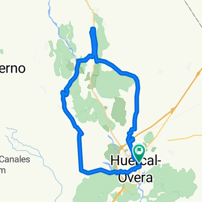
A cycling route starting in Huercal Overa, Andalusia, Spain.
Overview
About this route
Subida a Cazorla desde Overa, por Baza
- -:--
- Duration
- 179.1 km
- Distance
- 1,899 m
- Ascent
- 1,382 m
- Descent
- ---
- Avg. speed
- ---
- Max. altitude

Route quality
Waytypes & surfaces along the route
Waytypes
Busy road
75.8 km
(42 %)
Road
60.7 km
(34 %)
Surfaces
Paved
92.9 km
(52 %)
Unpaved
3.1 km
(2 %)
Asphalt
92.3 km
(52 %)
Gravel
2.9 km
(2 %)
Continue with Bikemap
Use, edit, or download this cycling route
You would like to ride Up to Cazorla on road or customize it for your own trip? Here is what you can do with this Bikemap route:
Free features
- Save this route as favorite or in collections
- Copy & plan your own version of this route
- Split it into stages to create a multi-day tour
- Sync your route with Garmin or Wahoo
Premium features
Free trial for 3 days, or one-time payment. More about Bikemap Premium.
- Navigate this route on iOS & Android
- Export a GPX / KML file of this route
- Create your custom printout (try it for free)
- Download this route for offline navigation
Discover more Premium features.
Get Bikemap PremiumFrom our community
Other popular routes starting in Huercal Overa
 HO - Sierrecica - Piruli (Indalbike)
- Distance
- 42.4 km
- Ascent
- 807 m
- Descent
- 810 m
- Location
- Huercal Overa, Andalusia, Spain
 Subida cerca de los Gazquez
- Distance
- 42.9 km
- Ascent
- 710 m
- Descent
- 712 m
- Location
- Huercal Overa, Andalusia, Spain
 Huercal Overa-Tetica de Bacares. 4550m en 171,3km con 3700m en 110km
- Distance
- 171.3 km
- Ascent
- 5,324 m
- Descent
- 3,517 m
- Location
- Huercal Overa, Andalusia, Spain
 Ruta Los Velez
- Distance
- 136.8 km
- Ascent
- 1,477 m
- Descent
- 1,494 m
- Location
- Huercal Overa, Andalusia, Spain
 RUTA ESTANCO Nº3 HUÉRCAL-OVERA
- Distance
- 67.3 km
- Ascent
- 531 m
- Descent
- 527 m
- Location
- Huercal Overa, Andalusia, Spain
 Huercal-Overa_Taberno
- Distance
- 34.4 km
- Ascent
- 468 m
- Descent
- 468 m
- Location
- Huercal Overa, Andalusia, Spain
 Training Route 2 Taberno loop
- Distance
- 78.8 km
- Ascent
- 1,475 m
- Descent
- 1,542 m
- Location
- Huercal Overa, Andalusia, Spain
 Giviley-El perellon-La Hoya-Almajalejo
- Distance
- 37.9 km
- Ascent
- 519 m
- Descent
- 478 m
- Location
- Huercal Overa, Andalusia, Spain
Open it in the app