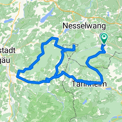
- 20 km
- 909 m
- 909 m
- Pfronten, Bavaria, Germany
Pfronten - eBike Voralpentour, Allgäu (Deutschland)
A cycling route starting in Pfronten, Bavaria, Germany.
Overview
About this route
Schwierigkeit: leicht Ausgangspunkt: Haus des Gastes Beschreibung: Streckenverlauf: Haus des Gastes, Pfronten-Röfleuten, Einfänge, Pfronten-Kappel, Moosmühlweg, Pfronten-Rehbichl, Schweinegg, Kögelhof/Kögelweiher, Schweinegg, Zell, Pfronten-Kreuzegg, Moosweg Wegbeschreibung: Asphalt und Schotter Höchster Punkt: 947 m Tipps: Gemütliche Radtour durch die sanft hügelige Voralpenlandschaft mit Bademöglichkeit und Besichtigung der Burgen "Hohenfreyberg" und "Eisenberg". Parken: In unmittelbarer Nähe der Tourist Information liegt das kostenpflichtige Parkhaus P5 „City / Sparkasse“.
- -:--
- Duration
- 21 km
- Distance
- 272 m
- Ascent
- 270 m
- Descent
- ---
- Avg. speed
- ---
- Max. altitude
created this 10 years ago
Route quality
Waytypes & surfaces along the route
Waytypes
Quiet road
15.3 km
(73 %)
Track
2.1 km
(10 %)
Surfaces
Paved
19.3 km
(92 %)
Unpaved
1 km
(5 %)
Asphalt
18 km
(86 %)
Paved (undefined)
1.3 km
(6 %)
Continue with Bikemap
Use, edit, or download this cycling route
You would like to ride Pfronten - eBike Voralpentour, Allgäu (Deutschland) or customize it for your own trip? Here is what you can do with this Bikemap route:
Free features
- Save this route as favorite or in collections
- Copy & plan your own version of this route
- Sync your route with Garmin or Wahoo
Premium features
Free trial for 3 days, or one-time payment. More about Bikemap Premium.
- Navigate this route on iOS & Android
- Export a GPX / KML file of this route
- Create your custom printout (try it for free)
- Download this route for offline navigation
Discover more Premium features.
Get Bikemap PremiumFrom our community
Other popular routes starting in Pfronten
- Breitenbergrunde
- Route in Pfronten
- 107.4 km
- 2,354 m
- 2,354 m
- Pfronten, Bavaria, Germany
- Ländle Runde
- 48.1 km
- 325 m
- 325 m
- Pfronten, Bavaria, Germany
- Pfronten–Gaichtpass–Reutte–Namlos–Gaichtpass–Pfronten
- 107.1 km
- 1,247 m
- 1,247 m
- Pfronten, Bavaria, Germany
- Rundroute Tannheimer Tal
- 62 km
- 1,124 m
- 842 m
- Pfronten, Bavaria, Germany
- König-Ludwig-Runde von Pfronten Steinach
- 118.6 km
- 589 m
- 587 m
- Pfronten, Bavaria, Germany
- Route in Pfronten
- 18.2 km
- 145 m
- 137 m
- Pfronten, Bavaria, Germany
- 7-Weiher-Runde
- 26.9 km
- 257 m
- 256 m
- Pfronten, Bavaria, Germany
Open it in the app


