

10-10-2013_Day37
A cycling route starting in Suwa, Nagano, Japan.
Overview
About this route
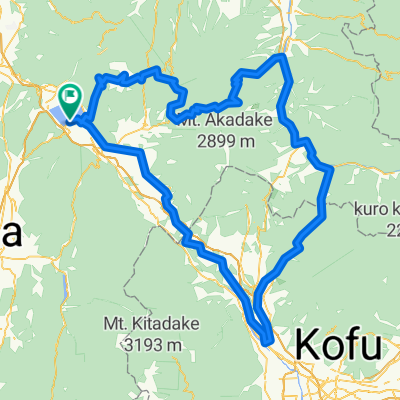
10-10-2013_Day37
諏訪市 -> 松本市 長野県- -:--
- Duration
- 62.3 km
- Distance
- 293 m
- Ascent
- 1,352 m
- Descent
- ---
- Avg. speed
- ---
- Max. altitude

Continue with Bikemap
Use, edit, or download this cycling route
You would like to ride 10-10-2013_Day37 or customize it for your own trip? Here is what you can do with this Bikemap route:
Free features
- Save this route as favorite or in collections
- Copy & plan your own version of this route
- Sync your route with Garmin or Wahoo
Premium features
Free trial for 3 days, or one-time payment. More about Bikemap Premium.
- Navigate this route on iOS & Android
- Export a GPX / KML file of this route
- Create your custom printout (try it for free)
- Download this route for offline navigation
Discover more Premium features.
Get Bikemap PremiumFrom our community
Other popular routes starting in Suwa
 BRM200km A案
- Distance
- 205.8 km
- Ascent
- 3,342 m
- Descent
- 3,341 m
- Location
- Suwa, Nagano, Japan
 諏訪湖1周
諏訪湖1周- Distance
- 17.5 km
- Ascent
- 38 m
- Descent
- 35 m
- Location
- Suwa, Nagano, Japan
 諏訪湖1周, 諏訪市
- Distance
- 16.2 km
- Ascent
- 18 m
- Descent
- 18 m
- Location
- Suwa, Nagano, Japan
 C絶景ビーナスラインルート
- Distance
- 58.9 km
- Ascent
- 1,686 m
- Descent
- 1,677 m
- Location
- Suwa, Nagano, Japan
 10-09-2013_Day36
- Distance
- 18.3 km
- Ascent
- 682 m
- Descent
- 254 m
- Location
- Suwa, Nagano, Japan
 蓼科牧場 to 白樺湖、女神湖 立科町
- Distance
- 16.8 km
- Ascent
- 284 m
- Descent
- 286 m
- Location
- Suwa, Nagano, Japan
 jkjl,
jkjl,- Distance
- 145.9 km
- Ascent
- 1,759 m
- Descent
- 2,164 m
- Location
- Suwa, Nagano, Japan
 Day 09:Shirakabako-Kawaguchiko
- Distance
- 125.5 km
- Ascent
- 2,341 m
- Descent
- 2,941 m
- Location
- Suwa, Nagano, Japan
Open it in the app