

Tuttlingen-Sigmaringen
A cycling route starting in Tuttlingen, Baden-Wurttemberg, Germany.
Overview
About this route
Tuttlingen downstream to Sigmaringen.
- -:--
- Duration
- 57.9 km
- Distance
- 291 m
- Ascent
- 360 m
- Descent
- ---
- Avg. speed
- ---
- Max. altitude
Route quality
Waytypes & surfaces along the route
Waytypes
Track
26.6 km
(46 %)
Path
11 km
(19 %)
Surfaces
Paved
41.7 km
(72 %)
Unpaved
15.6 km
(27 %)
Asphalt
37 km
(64 %)
Gravel
11.6 km
(20 %)
Continue with Bikemap
Use, edit, or download this cycling route
You would like to ride Tuttlingen-Sigmaringen or customize it for your own trip? Here is what you can do with this Bikemap route:
Free features
- Save this route as favorite or in collections
- Copy & plan your own version of this route
- Sync your route with Garmin or Wahoo
Premium features
Free trial for 3 days, or one-time payment. More about Bikemap Premium.
- Navigate this route on iOS & Android
- Export a GPX / KML file of this route
- Create your custom printout (try it for free)
- Download this route for offline navigation
Discover more Premium features.
Get Bikemap PremiumFrom our community
Other popular routes starting in Tuttlingen
 Kirchberg Seitingen
- Distance
- 39.6 km
- Ascent
- 270 m
- Descent
- 275 m
- Location
- Tuttlingen, Baden-Wurttemberg, Germany
 Zeughausstraße, Tuttlingen to Neue Straße, Ulm
- Distance
- 126.1 km
- Ascent
- 627 m
- Descent
- 796 m
- Location
- Tuttlingen, Baden-Wurttemberg, Germany
 Große Heubergrundfahrt
- Distance
- 63.9 km
- Ascent
- 346 m
- Descent
- 347 m
- Location
- Tuttlingen, Baden-Wurttemberg, Germany
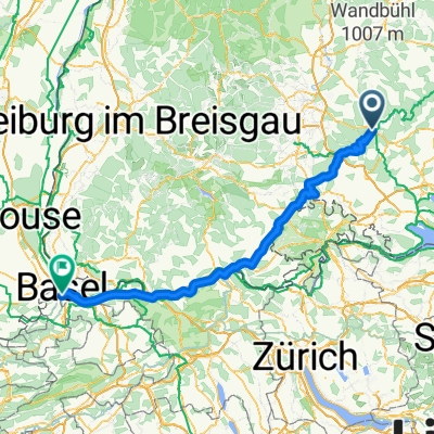 Tuttlingen Basel
- Distance
- 143.4 km
- Ascent
- 497 m
- Descent
- 873 m
- Location
- Tuttlingen, Baden-Wurttemberg, Germany
 Tuttlingen - Radolfzell - Schaffhausen
- Distance
- 75.5 km
- Ascent
- 1,067 m
- Descent
- 1,321 m
- Location
- Tuttlingen, Baden-Wurttemberg, Germany
 Baar-Bodensee-Hegau
- Distance
- 139.2 km
- Ascent
- 1,590 m
- Descent
- 1,592 m
- Location
- Tuttlingen, Baden-Wurttemberg, Germany
 Von Tuttlingen zum Dreifaligkeitsberg und über Spaichingen zurück
- Distance
- 36.6 km
- Ascent
- 434 m
- Descent
- 432 m
- Location
- Tuttlingen, Baden-Wurttemberg, Germany
 Verdauungsfahrt Stock Und Stein
- Distance
- 5.7 km
- Ascent
- 85 m
- Descent
- 85 m
- Location
- Tuttlingen, Baden-Wurttemberg, Germany
Open it in the app