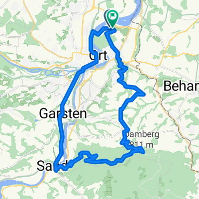
Radrunde durch Haidershofen
- 14.1 km
- 128 m
- 129 m
- Haidershofen, Lower Austria, Austria
A cycling route starting in Haidershofen, Lower Austria, Austria.
Overview
From the center of the village of Dietach, one travels a few meters northeast on the church square until reaching the street Pfarrberg. One now climbs very steeply up this road. After the ascent, however, the path is extremely pleasant, continuing on Pfarrberg to the Heuberger Straße (L1350), where one turns left. At the roundabout with the L1349, one takes a right, then switches sides to the bike path, turning left at the next opportunity (at the Landhaus Essl). Now one travels between two farms and reaches an unpaved path that leads through fields and woods before merging into a small junction. Here, one keeps left, already having the Wolferner church tower in sight, follows the course of the road, passing the outdoor pool, keeps left uphill on Kirchenstraße, and is already at the village center with the municipal office.
Duration: about 15 minutes
created this 10 years ago
Route quality
Quiet road
2.4 km
58 %
Track
1 km
24 %
Road
0.8 km
18 %
Paved
0.5 km
(12 %)
Unpaved
1 km
(24 %)
Gravel
1 km
24 %
Asphalt
0.5 km
12 %
Undefined
2.7 km
64 %
Continue with Bikemap
You would like to ride Dietach - Wolfern (Ortszentren, Umgehung von Hauptverkehrsstraßen) or customize it for your own trip? Here is what you can do with this Bikemap route:
Free trial for 3 days, or one-time payment. More about Bikemap Premium.
Discover more Premium features.
Get Bikemap PremiumFrom our community
Open it in the app