
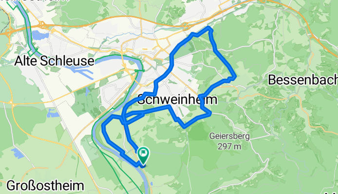
Obernau-Goldbach-Haibach-Schweinheim-Obernau
A cycling route starting in Niedernberg, Bavaria, Germany.
Overview
About this route
from Jahnstrasse in Obernau via Schweinheim to Aschaffenburg and Goldbach, through Obergartenhof and Schellenmühle into Haibach Switzerland, Haibach, Würzburger Strasse, Schweinheim (past the Italian place) up to Bischberg, detour to Ludwigstempel, Obernauer Flur, Mainfeldstrasse, along the Main until the underpass, back to Jahnstrasse
- -:--
- Duration
- 27.7 km
- Distance
- 213 m
- Ascent
- 216 m
- Descent
- ---
- Avg. speed
- ---
- Max. altitude

Route quality
Waytypes & surfaces along the route
Waytypes
Track
11.1 km
(40 %)
Quiet road
7.2 km
(26 %)
Surfaces
Paved
16.9 km
(61 %)
Unpaved
6.4 km
(23 %)
Asphalt
15 km
(54 %)
Gravel
3.9 km
(14 %)
Continue with Bikemap
Use, edit, or download this cycling route
You would like to ride Obernau-Goldbach-Haibach-Schweinheim-Obernau or customize it for your own trip? Here is what you can do with this Bikemap route:
Free features
- Save this route as favorite or in collections
- Copy & plan your own version of this route
- Sync your route with Garmin or Wahoo
Premium features
Free trial for 3 days, or one-time payment. More about Bikemap Premium.
- Navigate this route on iOS & Android
- Export a GPX / KML file of this route
- Create your custom printout (try it for free)
- Download this route for offline navigation
Discover more Premium features.
Get Bikemap PremiumFrom our community
Other popular routes starting in Niedernberg
 Obernau-Goldbach-Haibach-Schweinheim-Obernau
- Distance
- 27.7 km
- Ascent
- 213 m
- Descent
- 216 m
- Location
- Niedernberg, Bavaria, Germany
 200719 Rundweg von JA über Sulzbach zur hohen Warte
- Distance
- 31.3 km
- Ascent
- 524 m
- Descent
- 525 m
- Location
- Niedernberg, Bavaria, Germany
 Lange Ausfahrt durch Wertheim
- Distance
- 62 km
- Ascent
- 584 m
- Descent
- 567 m
- Location
- Niedernberg, Bavaria, Germany
 Radrunde durch Aschaffenburg
- Distance
- 18.9 km
- Ascent
- 261 m
- Descent
- 261 m
- Location
- Niedernberg, Bavaria, Germany
 Mornigtour
- Distance
- 29.2 km
- Ascent
- 41 m
- Descent
- 40 m
- Location
- Niedernberg, Bavaria, Germany
 Von Niedernberg nach Wertheim-Bettingen
- Distance
- 55.8 km
- Ascent
- 766 m
- Descent
- 668 m
- Location
- Niedernberg, Bavaria, Germany
 Ausfahrt durch Aschaffenburg
- Distance
- 18.3 km
- Ascent
- 200 m
- Descent
- 203 m
- Location
- Niedernberg, Bavaria, Germany
 2020-09-13: Niedernberg - Miltenberg
- Distance
- 80 km
- Ascent
- 511 m
- Descent
- 507 m
- Location
- Niedernberg, Bavaria, Germany
Open it in the app