

Rundkurs westlich von Ulm
A cycling route starting in Ulm, Baden-Württemberg, Germany.
Overview
About this route
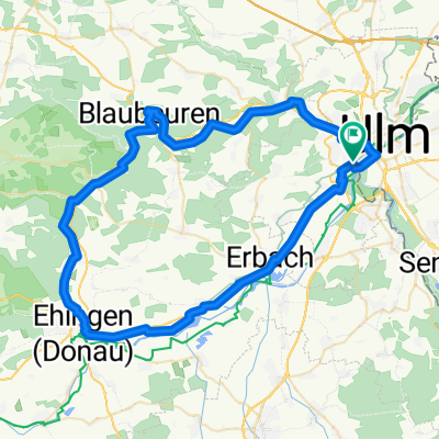
<span style="font-family: Arial, Helvetica, sans-serif; font-size: 11px;">Startend in der Ulmer Innenstadt geht es zunächst Richtung Donau. Flussaufwärts fährt man bis an den Beginn des Industriegebiets Donautal, dann nördlich die Lindenhöhe hinauf und weiter bis zum Fort Oberer Kuhberg. Dort oben angekommen geht es westlich über Feldwege in Richtung Allewind. Danach kreuz und quer durch die Felder und Wälder nach Arnegg. Von dort geht der Rückweg nach Osten los. In Blaustein fährt man einen schönen Radweg entlang der Blau. Dann geht es auf einem langgezogenen Radweg parallel zu den Schienen zurück nach Ulm.</span>
- -:--
- Duration
- 27.1 km
- Distance
- 254 m
- Ascent
- 257 m
- Descent
- ---
- Avg. speed
- ---
- Avg. speed

Route highlights
Points of interest along the route

Photo after 14.2 km
Continue with Bikemap
Use, edit, or download this cycling route
You would like to ride Rundkurs westlich von Ulm or customize it for your own trip? Here is what you can do with this Bikemap route:
Free features
- Save this route as favorite or in collections
- Copy & plan your own version of this route
- Sync your route with Garmin or Wahoo
Premium features
Free trial for 3 days, or one-time payment. More about Bikemap Premium.
- Navigate this route on iOS & Android
- Export a GPX / KML file of this route
- Create your custom printout (try it for free)
- Download this route for offline navigation
Discover more Premium features.
Get Bikemap PremiumFrom our community
Other popular routes starting in Ulm
 Blaustein-Örlingen-Donau
- Distance
- 28.9 km
- Ascent
- 222 m
- Descent
- 219 m
- Location
- Ulm, Baden-Württemberg, Germany
 25 km Trainingsroute Ulm
- Distance
- 25.1 km
- Ascent
- 90 m
- Descent
- 87 m
- Location
- Ulm, Baden-Württemberg, Germany
 Donauradweg Ulm nach Passa_TheBest
- Distance
- 386.8 km
- Ascent
- 175 m
- Descent
- 351 m
- Location
- Ulm, Baden-Württemberg, Germany
 Ulm-Donau-Bodensee-Iller
- Distance
- 405.6 km
- Ascent
- 754 m
- Descent
- 753 m
- Location
- Ulm, Baden-Württemberg, Germany
 Ulm - Firedrichshafen (Bodensee)
- Distance
- 131.3 km
- Ascent
- 929 m
- Descent
- 969 m
- Location
- Ulm, Baden-Württemberg, Germany
 Trainingsfahrt im Ulmer Norden
- Distance
- 35.6 km
- Ascent
- 337 m
- Descent
- 340 m
- Location
- Ulm, Baden-Württemberg, Germany
 Ulm_Kempten_Lindau
- Distance
- 190.1 km
- Ascent
- 1,603 m
- Descent
- 1,682 m
- Location
- Ulm, Baden-Württemberg, Germany
 Ulm - Blaubeuren - Ehingen - Erbach - Ulm
- Distance
- 68.1 km
- Ascent
- 266 m
- Descent
- 266 m
- Location
- Ulm, Baden-Württemberg, Germany
Open it in the app