

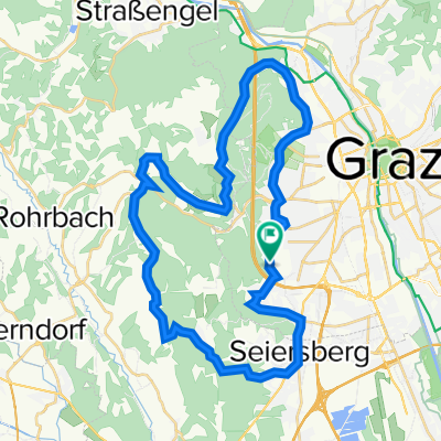
Graz->Seiersberg
A cycling route starting in Wetzelsdorf, Styria, Austria.
Overview
About this route
Schöner Landschaftsweg in Richtung Seiersberg
- -:--
- Duration
- 9.7 km
- Distance
- 90 m
- Ascent
- 237 m
- Descent
- ---
- Avg. speed
- 495 m
- Avg. speed
Route quality
Waytypes & surfaces along the route
Waytypes
Road
4 km
(41 %)
Quiet road
3 km
(31 %)
Surfaces
Paved
8.7 km
(90 %)
Unpaved
0.2 km
(2 %)
Asphalt
7.9 km
(82 %)
Paved (undefined)
0.8 km
(8 %)
Continue with Bikemap
Use, edit, or download this cycling route
You would like to ride Graz->Seiersberg or customize it for your own trip? Here is what you can do with this Bikemap route:
Free features
- Save this route as favorite or in collections
- Copy & plan your own version of this route
- Sync your route with Garmin or Wahoo
Premium features
Free trial for 3 days, or one-time payment. More about Bikemap Premium.
- Navigate this route on iOS & Android
- Export a GPX / KML file of this route
- Create your custom printout (try it for free)
- Download this route for offline navigation
Discover more Premium features.
Get Bikemap PremiumFrom our community
Other popular routes starting in Wetzelsdorf
 Graz - Schachblume - Gleisdorf
- Distance
- 96.2 km
- Ascent
- 568 m
- Descent
- 596 m
- Location
- Wetzelsdorf, Styria, Austria
 Mantscha
- Distance
- 37.2 km
- Ascent
- 537 m
- Descent
- 538 m
- Location
- Wetzelsdorf, Styria, Austria
 Kleiner Rundkurs - Grazer Westen
- Distance
- 22 km
- Ascent
- 389 m
- Descent
- 389 m
- Location
- Wetzelsdorf, Styria, Austria
 Mantscha-Umrundung
- Distance
- 28 km
- Ascent
- 455 m
- Descent
- 401 m
- Location
- Wetzelsdorf, Styria, Austria
 Graz nach Villach über Mur und Drau
- Distance
- 268.9 km
- Ascent
- 686 m
- Descent
- 548 m
- Location
- Wetzelsdorf, Styria, Austria
 Cecis 2
- Distance
- 22.4 km
- Ascent
- 598 m
- Descent
- 591 m
- Location
- Wetzelsdorf, Styria, Austria
 Graz Tobelbad Schwarzl Graz
- Distance
- 35.4 km
- Ascent
- 297 m
- Descent
- 297 m
- Location
- Wetzelsdorf, Styria, Austria
 Gemütlich rund um den Plabutsch
- Distance
- 14.4 km
- Ascent
- 240 m
- Descent
- 241 m
- Location
- Wetzelsdorf, Styria, Austria
Open it in the app