

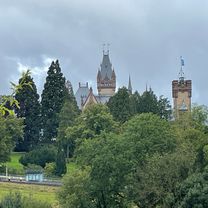
Bonn - Stadt Blankenberg
A cycling route starting in Bonn, North Rhine-Westphalia, Germany.
Overview
About this route
Beautiful route through the Siebengebirge with a few short but steep climbs and fast descents.
- -:--
- Duration
- 79.5 km
- Distance
- 846 m
- Ascent
- 846 m
- Descent
- ---
- Avg. speed
- ---
- Max. altitude

Route quality
Waytypes & surfaces along the route
Waytypes
Road
23.9 km
(30 %)
Quiet road
15.9 km
(20 %)
Surfaces
Paved
55.7 km
(70 %)
Unpaved
1.6 km
(2 %)
Asphalt
51.7 km
(65 %)
Paved (undefined)
3.2 km
(4 %)
Continue with Bikemap
Use, edit, or download this cycling route
You would like to ride Bonn - Stadt Blankenberg or customize it for your own trip? Here is what you can do with this Bikemap route:
Free features
- Save this route as favorite or in collections
- Copy & plan your own version of this route
- Sync your route with Garmin or Wahoo
Premium features
Free trial for 3 days, or one-time payment. More about Bikemap Premium.
- Navigate this route on iOS & Android
- Export a GPX / KML file of this route
- Create your custom printout (try it for free)
- Download this route for offline navigation
Discover more Premium features.
Get Bikemap PremiumFrom our community
Other popular routes starting in Bonn
 Ahrtal-Eifel-Kottenforst
- Distance
- 80.9 km
- Ascent
- 925 m
- Descent
- 910 m
- Location
- Bonn, North Rhine-Westphalia, Germany
 Winterfeierabendrunde an die Sieg
- Distance
- 39.5 km
- Ascent
- 182 m
- Descent
- 182 m
- Location
- Bonn, North Rhine-Westphalia, Germany
 Bonn Posttower - Siebengebirge
- Distance
- 62 km
- Ascent
- 672 m
- Descent
- 675 m
- Location
- Bonn, North Rhine-Westphalia, Germany
 Leichte MTB Abendrunde mit viel Abwechslung
- Distance
- 31.9 km
- Ascent
- 275 m
- Descent
- 281 m
- Location
- Bonn, North Rhine-Westphalia, Germany
 BRT2016-DI: Ins Drachenfelser Ländchen - PSF des Radsportbezirk Mittelrhein-Süd beim BRT 2016 in Bonn - 71 km Strecke
- Distance
- 72.5 km
- Ascent
- 609 m
- Descent
- 610 m
- Location
- Bonn, North Rhine-Westphalia, Germany
 Venusbergtour 02
- Distance
- 17.5 km
- Ascent
- 289 m
- Descent
- 280 m
- Location
- Bonn, North Rhine-Westphalia, Germany
 Drachenfels-Milchhäuschen
- Distance
- 38.8 km
- Ascent
- 588 m
- Descent
- 585 m
- Location
- Bonn, North Rhine-Westphalia, Germany
 BRT2016-SA: westwärts.. - RTF des Radsportbezirk Mittelrhein-Süd beim BRT 2016 in Bonn - 100 km Strecke einer Super-Pfeil-Such-Fahrt
- Distance
- 100.8 km
- Ascent
- 222 m
- Descent
- 222 m
- Location
- Bonn, North Rhine-Westphalia, Germany
Open it in the app