

10-20-2013_Day47
A cycling route starting in Nabari, Mie, Japan.
Overview
About this route
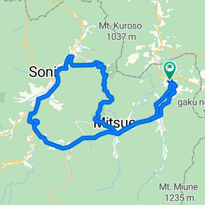
10-20-2013_Day47
名張 -> 奈良- -:--
- Duration
- 54.6 km
- Distance
- 253 m
- Ascent
- 396 m
- Descent
- ---
- Avg. speed
- ---
- Max. altitude

Continue with Bikemap
Use, edit, or download this cycling route
You would like to ride 10-20-2013_Day47 or customize it for your own trip? Here is what you can do with this Bikemap route:
Free features
- Save this route as favorite or in collections
- Copy & plan your own version of this route
- Sync your route with Garmin or Wahoo
Premium features
Free trial for 3 days, or one-time payment. More about Bikemap Premium.
- Navigate this route on iOS & Android
- Export a GPX / KML file of this route
- Create your custom printout (try it for free)
- Download this route for offline navigation
Discover more Premium features.
Get Bikemap PremiumFrom our community
Other popular routes starting in Nabari
 Day 600
- Distance
- 74.8 km
- Ascent
- 487 m
- Descent
- 686 m
- Location
- Nabari, Mie, Japan
 2020_09_05 御杖_曽爾サイクリング
- Distance
- 31.1 km
- Ascent
- 956 m
- Descent
- 956 m
- Location
- Nabari, Mie, Japan
 伊賀南コース(忍びの里サイクリングコース)
- Distance
- 51.5 km
- Ascent
- 753 m
- Descent
- 752 m
- Location
- Nabari, Mie, Japan
 DAY 3
DAY 3- Distance
- 73.2 km
- Ascent
- 851 m
- Descent
- 937 m
- Location
- Nabari, Mie, Japan
 650-5, Akamecho Nagasaka, Nabari to 688-19, Kuzumotocho, Kashihara
- Distance
- 50.4 km
- Ascent
- 520 m
- Descent
- 763 m
- Location
- Nabari, Mie, Japan
 10-20-2013_Day47
- Distance
- 54.6 km
- Ascent
- 253 m
- Descent
- 396 m
- Location
- Nabari, Mie, Japan
 神末6330, 宇陀郡御杖村 to 垂水1983, 津市
- Distance
- 46.6 km
- Ascent
- 419 m
- Descent
- 868 m
- Location
- Nabari, Mie, Japan
 317, Fukigaoka 5Bancho, Nabari-Shi to Biwako-ohashi Toll Road, Otsu-Shi
- Distance
- 76.5 km
- Ascent
- 439 m
- Descent
- 604 m
- Location
- Nabari, Mie, Japan
Open it in the app