

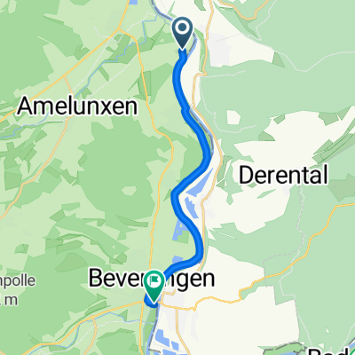
Wehrden Rundtour
A cycling route starting in Fürstenberg, Lower Saxony, Germany.
Overview
About this route
X
(cloned from route 2972430)
- -:--
- Duration
- 42.5 km
- Distance
- 554 m
- Ascent
- 554 m
- Descent
- ---
- Avg. speed
- ---
- Max. altitude
Route quality
Waytypes & surfaces along the route
Waytypes
Road
14.6 km
(34 %)
Track
7.9 km
(19 %)
Surfaces
Paved
28 km
(66 %)
Unpaved
0.4 km
(1 %)
Asphalt
26.5 km
(62 %)
Paving stones
1.2 km
(3 %)
Continue with Bikemap
Use, edit, or download this cycling route
You would like to ride Wehrden Rundtour or customize it for your own trip? Here is what you can do with this Bikemap route:
Free features
- Save this route as favorite or in collections
- Copy & plan your own version of this route
- Sync your route with Garmin or Wahoo
Premium features
Free trial for 3 days, or one-time payment. More about Bikemap Premium.
- Navigate this route on iOS & Android
- Export a GPX / KML file of this route
- Create your custom printout (try it for free)
- Download this route for offline navigation
Discover more Premium features.
Get Bikemap PremiumFrom our community
Other popular routes starting in Fürstenberg
 Godelheimer Straße, Beverungen nach An der Burg, Beverungen
- Distance
- 9.4 km
- Ascent
- 9 m
- Descent
- 9 m
- Location
- Fürstenberg, Lower Saxony, Germany
 Entlang der Weser zwischen Höxter und Bad Karlshafen
- Distance
- 63 km
- Ascent
- 311 m
- Descent
- 311 m
- Location
- Fürstenberg, Lower Saxony, Germany
 Fürstenberg - Holzminden - Höxter - Fürstenberg
- Distance
- 40.7 km
- Ascent
- 188 m
- Descent
- 189 m
- Location
- Fürstenberg, Lower Saxony, Germany
 Wehrden - Beverungen
- Distance
- 39.7 km
- Ascent
- 440 m
- Descent
- 428 m
- Location
- Fürstenberg, Lower Saxony, Germany
 wehrden-Hann-Münden
- Distance
- 58.7 km
- Ascent
- 400 m
- Descent
- 368 m
- Location
- Fürstenberg, Lower Saxony, Germany
 Wehrden Rundtour
- Distance
- 42.5 km
- Ascent
- 554 m
- Descent
- 554 m
- Location
- Fürstenberg, Lower Saxony, Germany
 9/München-Bremen
- Distance
- 103 km
- Ascent
- 215 m
- Descent
- 351 m
- Location
- Fürstenberg, Lower Saxony, Germany
 Löhneweg 3, Beverungen nach Stummrigestraße 47, Höxter
- Distance
- 9.5 km
- Ascent
- 3 m
- Descent
- 15 m
- Location
- Fürstenberg, Lower Saxony, Germany
Open it in the app